Mauna_Loa_atmospheric_transmission.png
No higher resolution available.

|
This
graph
image could be re-created
using
vector graphics
as an
SVG
file
. This has several advantages; see
Commons:Media for cleanup
for more information. If an SVG form of this image is available, please upload it and afterwards replace this template with
{{

vector version available

|

new image name

}}
.
It is recommended to name the SVG file “Mauna Loa atmospheric transmission.svg”—then the template Vector version available (or Vva ) does not need the new image name parameter. |
Summary
English:
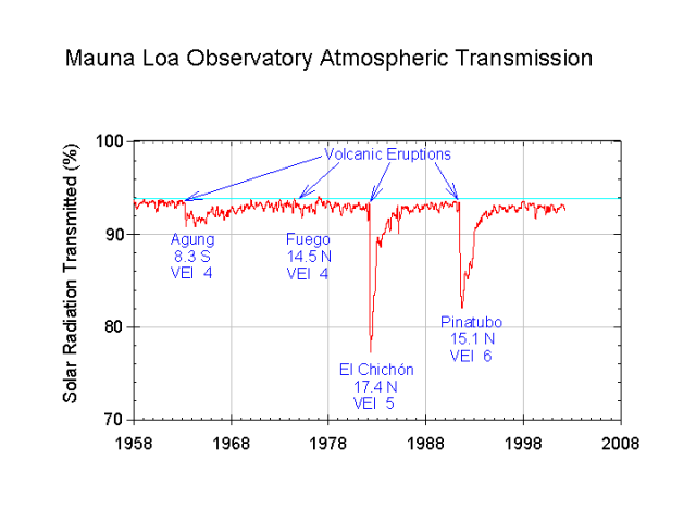
Mauna Loa Observatory
atmospheric transmission. Reduced solar radiation due to
volcanic
aerosols
labeled.
Español:
Transmisión atmosférica del Observatorio de Mauna Loa en Hawaii. Reducción de la radiación solar debido a las erupciones volcánicas del Monte Agung (1963, Indonesia), Volcán de Fuego (1974, Guatemala), El Chichón (1982, México), Monte Pinatubo (1991, Filipinas).
|
|
This image is in the
public domain
because it contains materials that originally came from the U.S.
National Oceanic and Atmospheric Administration
, taken or made as part of an employee's official duties.
|
|
Source: http://www.cmdl.noaa.gov/albums/cmdl_overview/Slide18.sized.png