Mongol_Empire_c.1207.png

Size of this preview:
800 × 523 pixels
.
Other resolutions:
320 × 209 pixels
|
640 × 419 pixels
|
813 × 532 pixels
.
Summary
| Description |
English:
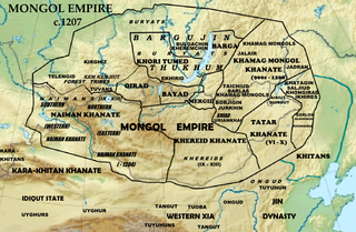
Map of the homelands of the tribes of the Mongol Empire in 1207 and preceding polities. Based on
File:Asia laea relief location map.jpg
.
|
| Date | |
| Source | Data source: "Mongolian National Atlas", 2009; Atwood, Christopher P. (2004) Encyclopedia of Mongolia and the Mongol Empire , Facts on File, p. 390 ISBN : 978-0-8160-4671-3 . |
| Author | Khiruge |
Licensing
I, the copyright holder of this work, hereby publish it under the following license:
This file is licensed under the
Creative Commons
Attribution-Share Alike 4.0 International
license.
-
You are free:
- to share – to copy, distribute and transmit the work
- to remix – to adapt the work
-
Under the following conditions:
- attribution – You must give appropriate credit, provide a link to the license, and indicate if changes were made. You may do so in any reasonable manner, but not in any way that suggests the licensor endorses you or your use.
- share alike – If you remix, transform, or build upon the material, you must distribute your contributions under the same or compatible license as the original.