MulberryB_-_Piers.jpg


Summary

Description

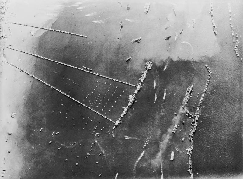
An aerial view of the pierhead and breakwater at the artificial 'Mulberry B Harbour' at Arromanches (Goosberry 3).

Original description: "Allied Harbour Mulberry B: This photo shows the roadways and spud pierheads of the West Pier, Central Pier and East Pier. The small dots beside the roadways are barges supporting a cable used to protect the piers from small craft. A partial view of the Blockships and PHOENIX is obtainable. The calm water in the harbour can again be noted."
Date
Source
This photograph C 4626 comes from the collections of the Imperial War Museums .
Author Royal Air Force official photographer
Other versions ibiblio.org a collaboration of the centerforthepublicdomain.org
Camera location 49° 21′ 09″ N, 0° 37′ 40″ W Kartographer map based on OpenStreetMap. View this and other nearby images on: OpenStreetMap info

Licensing

Public domain
This work created by the United Kingdom Government is in the public domain .

This is because it is one of the following :

  1. It is a photograph taken prior to 1 June 1957; or
  2. It was published prior to 1974; or
  3. It is an artistic work other than a photograph or engraving (e.g. a painting) which was created prior to 1974.

HMSO has declared that the expiry of Crown Copyrights applies worldwide (ref: HMSO Email Reply )
More information .

See also Copyright and Crown copyright artistic works .

Deutsch English Español français italiano Nederlands polski português sicilianu slovenščina suomi Türkçe македонски русский українська മലയാളം 한국어 日本語 简体中文 繁體中文 العربية +/−

Captions

Add a one-line explanation of what this file represents

Items portrayed in this file

depicts

27 October 1944

49°21'9.000"N, 0°37'40.001"W