NeoHittiteStates.gif
No higher resolution available.
| Description |
English:
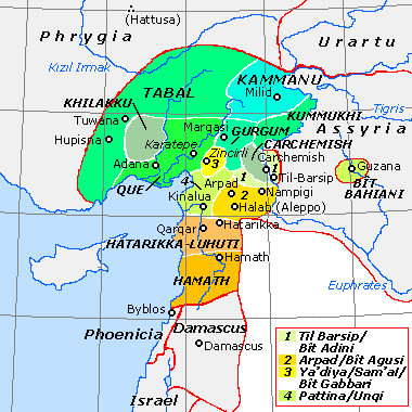
Historical map of the Neo-Hittite states (ca. 800 BCE). Based on data from Tübinger Bibelatlas (Tübinger Bible Atlas), S. Mittmann & G. Schmitt (eds.), maps B IV 13-14, and O.R. Gurney, The Hittites, Harmondsworth: Penguin (Pelican Books), 2nd ed., 1976 (=1954) pp. 39-46. "State borders" are approximate only.
|
||||||||
| Date | |||||||||
| Source | http://en.wikipedia.org/wiki/Image:NeoHittiteStates.gif | ||||||||
| Author | Hans van Deukeren ( talk ) | ||||||||
|
Permission
( Reusing this file ) |
|
