Newton_rebellion_stone_(geograph_4105909).jpg

Size of this preview:
400 × 600 pixels
.
Other resolutions:
160 × 240 pixels
|
320 × 480 pixels
|
683 × 1,024 pixels
.
Summary
| Description |
English:
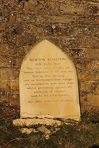
Newton rebellion stone by Newton Field Centre commemorating the Newton Rebellion on 8th June 1607.
In the early years of the reign of King James I, powerful midlands landowners started enclosing common land for their estates, locally this was the Treshams of Rushton and their cousins at Newton. Large protest gatherings of thousands of peasants took place, led by Captain Pouch and calling themselves diggers and levellers. James I issued a proclamation for the suppression of the Midland Revolt on 30th May 1607 and on 8th June a huge protest at Newton by over a thousand peasants was brutally dispersed by an army raised by the Treshams as over 40 of the protesters were killed. The ringleaders were captured and imprisoned in St.Faith's church before being tried, hanged and quartered.
|
| Date | |
| Source | From geograph.org.uk |
| Author | Richard Croft |
|
Permission
( Reusing this file ) |
Creative Commons Attribution Share-alike license 2.0 |
|
Attribution
( required by the license ) |
Richard Croft / Newton rebellion stone / |
| Camera location |
|
View this and other nearby images on: OpenStreetMap |
|
|---|
.jpg¶ms=052.440257_N_-000.700666_E_globe:Earth_type:camera_source:geograph-osgb36(SP88428327)_heading:90.00&language=en)
| Object location |
|
View this and other nearby images on: OpenStreetMap |
|
|---|
.jpg¶ms=052.440260_N_-000.700670_E_globe:Earth_class:object_type:object_source:geograph-osgb36(SP88428327)_heading:90.00&language=en)
Licensing

|
This image was taken from the
Geograph project
collection. See
this photograph's page
on the Geograph website for the photographer's contact details. The copyright on this image is owned by
Richard Croft
and is licensed for reuse under the
Creative Commons
Attribution-ShareAlike 2.0 license.
|
This file is licensed under the
Creative Commons
Attribution-Share Alike 2.0 Generic
license.
Attribution:
Richard Croft
-
You are free:
- to share – to copy, distribute and transmit the work
- to remix – to adapt the work
-
Under the following conditions:
- attribution – You must give appropriate credit, provide a link to the license, and indicate if changes were made. You may do so in any reasonable manner, but not in any way that suggests the licensor endorses you or your use.
- share alike – If you remix, transform, or build upon the material, you must distribute your contributions under the same or compatible license as the original.