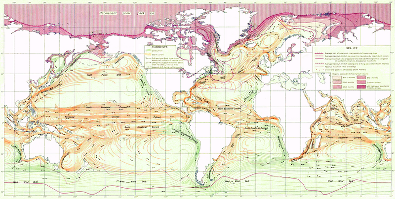
Ocean_currents_1943_(borderless)3.png

Size of this preview:
800 × 405 pixels
.
Other resolutions:
320 × 162 pixels
|
640 × 324 pixels
|
1,024 × 519 pixels
|
1,280 × 649 pixels
|
2,577 × 1,306 pixels
.

|
This
meteorology
image could be re-created
using
vector graphics
as an
SVG
file
. This has several advantages; see
Commons:Media for cleanup
for more information. If an SVG form of this image is available, please upload it and afterwards replace this template with
{{

vector version available

|

new image name

}}
.
It is recommended to name the SVG file “Ocean currents 1943 (borderless)3.svg”—then the template Vector version available (or Vva ) does not need the new image name parameter. |
Summary
| Description |
English:
Ocean Currents
and Sea Ice from Atlas of World Maps
,
United States Army
Service Forces, Army Specialized Training Division. Army Service Forces Manual M-101 (1943).
Türkçe:
Dünyanın büyük akıntılarının şeması
|
|||
| Date | ||||
| Source | Edited version of File:Ocean currents 1943 (borderless).png | |||
| Author | US army | |||
|
Permission
( Reusing this file ) |
|
|||
| Other versions |
This file was derived from:
Ocean currents 1943 (borderless).png
(For more versions see there) |

.png)
.png)
|
|
This is a
retouched picture
, which means that it has been digitally altered from its original version. Modifications:
landmass interiors clarified, some latitude and longitude lines repaired, bottom longitudinal numbering replaced, and a stray pencil mark through the Indian Ocean removed
. The original can be viewed here:
Ocean currents 1943 (borderless).png
:
|
Assessment
|
3.png)