Offshore_windpark_Thorntonbank.jpg

Size of this preview:
800 × 600 pixels
.
Other resolutions:
320 × 240 pixels
|
640 × 480 pixels
|
1,024 × 768 pixels
|
1,280 × 960 pixels
|
1,800 × 1,350 pixels
.
Summary
| Description Offshore windpark Thorntonbank.jpg |
Deutsch:
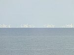
Foto des Offshore Windparks vor der belgischen Küste. Aus 50 km Entfernung (Westende) wird die Erkrümmung sehr deutlich.
English:
This picture of the offshore windpark in front of the Belgian coast perfectly shows the earth curvature.
Українська:
Фотографія електростанції з узбережжя Бельгії показує, як нижні частини більш віддалених вітряків поступово зникають за горизонтом демонструючи округлість Землі.
|
| Date | |
| Source | Own work |
| Author | Lieven |
| Other versions |
original image:

|
Licensing
I, the copyright holder of this work, hereby publish it under the following license:
This file is licensed under the
Creative Commons
Attribution-Share Alike 4.0 International
license.
-
You are free:
- to share – to copy, distribute and transmit the work
- to remix – to adapt the work
-
Under the following conditions:
- attribution – You must give appropriate credit, provide a link to the license, and indicate if changes were made. You may do so in any reasonable manner, but not in any way that suggests the licensor endorses you or your use.
- share alike – If you remix, transform, or build upon the material, you must distribute your contributions under the same or compatible license as the original.
Captions
At a distance of 50 km, it is visible how the Thorntonbank Wind Farm is hidden by the curvature of the earth.
Электрастанцыі з берагоў Бельгіі. З-за сферычнай формы Зямлі прыкметна паступовае знікненне за гарызонтам больш аддаленых ветракоў.
Aus ca. 50 km Entfernung werden die Rotorblätter der Thorntonbank Wind Farm durch die Erdkrümmung verdeckt.
50 km mesafede bulunan Thorntonbank Rüzgar Santrali direklerinin dünyanın eğriliği tarafından nasıl gizlendiği açıkça görülebiliyor.
