Ohridski-Map.PNG

Size of this preview:
475 × 600 pixels
.
Other resolutions:
190 × 240 pixels
|
380 × 480 pixels
|
608 × 768 pixels
|
811 × 1,024 pixels
|
1,622 × 2,048 pixels
|
2,849 × 3,598 pixels
.
Summary
| Description |
English:
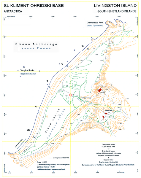
L.L. Ivanov, St. Kliment Ohridski Base, Livingston Island, 1:1 000 scale topographic map, Commissioned by the Antarctic Place-names Commission of Bulgaria, sponsored by the Atlantic Club of Bulgaria and the Bulgarian Antarctic Institute, Sofia, 1996. The first Bulgarian Antarctic topographic map.
Note
: 'New building' actually refers to the foundations of the new main building of the Bulgarian Base as of 1996; the building itself was completed in 1998.
|
| Date | |
| Source | Own work |
| Author | User:Apcbg |
| Other versions | File:Ohridski-Map.jpg |
| Camera location |
|
View this and other nearby images on: OpenStreetMap |
|
|---|
Licensing
I, the copyright holder of this work, hereby publish it under the following license:
This file is licensed under the
Creative Commons
Attribution-Share Alike 4.0 International
license.
-
You are free:
- to share – to copy, distribute and transmit the work
- to remix – to adapt the work
-
Under the following conditions:
- attribution – You must give appropriate credit, provide a link to the license, and indicate if changes were made. You may do so in any reasonable manner, but not in any way that suggests the licensor endorses you or your use.
- share alike – If you remix, transform, or build upon the material, you must distribute your contributions under the same or compatible license as the original.