Reading
Shortcuts
Home
All Articles
Read from Another Site
Sources
Wikipedia
Simple Wikipedia
VOA Learning English
Futurity
The Conversation
MIT News
Harvard Gazette
Cambridge News
YDS/YÖKDİL Passages
Topics
Technology
Engineering
Business
Economics
Human
Health
Energy
Biology
Nature
Space
Log in
Sign up
Peacearch-boundarymarkers.jpg
Size of this preview:
450 × 600 pixels
.
Other resolutions:
180 × 240 pixels
|
360 × 480 pixels
|
576 × 768 pixels
|
768 × 1,024 pixels
|
1,704 × 2,272 pixels
.
Description
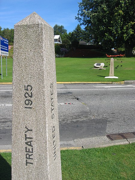
Peacearch-boundarymarkers.jpg
The international boundary markers (the two columns at each side of the road) at Peace Arch Park. Surrey, BC, Canada/Blaine, Washington, USA.
Date
28 August 2006
Source
Own work
Author
Arnold C (
User:Buchanan-Hermit
)
Permission
(
Reusing this file
)
The copyright holder of this file allows anyone to use it
for any purpose, provided that
the copyright holder is properly attributed. Redistribution, derivative work, commercial use, and all other use is permitted.
Attribution
Camera location
49° 00′ 07.56″ N, 122° 45′ 21.99″ W
View this and other nearby images on:
OpenStreetMap
49.002101; -122.756107
Captions
English
Add a one-line explanation of what this file represents
Items portrayed in this file
depicts
copyright status
copyrighted
copyright license
attribution only license
inception
28 August 2006
captured with
Canon Digital IXUS 400
coordinates of the point of view
49°0'7.564"N, 122°45'21.985"W
heading
:
157.5
degree
source of file
original creation by uploader

