Philadelphia_Map,_1777_Philadelphia_Campaign2.jpg

Size of this preview:
356 × 598 pixels
.
Other resolutions:
143 × 240 pixels
|
285 × 480 pixels
|
457 × 768 pixels
|
609 × 1,024 pixels
|
1,218 × 2,048 pixels
|
10,766 × 18,097 pixels
.
Summary
| Warning | The original file is very high-resolution. It might not load properly or could cause your browser to freeze when opened at full size. |
|---|
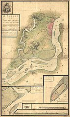
| Description |
English:
A survey of the city of Philadelphia and its environs shewing the several works constructed by His Majesty's troops, under the command of Sir
William Howe
, since their possession of that city 26th. September 1777, comprehending likewise the attacks against
Fort Mifflin
on Mud Island, and until it's reduction, 16th November 1777.
|
||
| Date | |||
| Source | Library of Congress | ||
| Author |
Contributor Names:
|
||
| Other versions |
|


Licensing
|
|
This work is in the public domain in its country of origin and other countries and areas where the copyright term is the author's life plus 70 years or fewer . This work is in the public domain in the United States because it was published (or registered with the U.S. Copyright Office ) before January 1, 1929. |
| This file has been identified as being free of known restrictions under copyright law, including all related and neighboring rights. | |