PrairiePotholeRegionMap.gif
No higher resolution available.
Summary

|
This
map
image could be re-created
using
vector graphics
as an
SVG
file
. This has several advantages; see
Commons:Media for cleanup
for more information. If an SVG form of this image is available, please upload it and afterwards replace this template with
{{

vector version available

|

new image name

}}
.
It is recommended to name the SVG file “PrairiePotholeRegionMap.svg”—then the template Vector version available (or Vva ) does not need the new image name parameter. |
| Description |
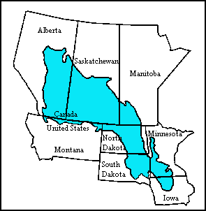
English:
Map of the Prairie Pothole Region of North America. From the US Geological Survey,
http://www.npwrc.usgs.gov/resource/wetlands/pothole/prairie.htm
|
| Source | |
| Author |
Licensing
|
|
This image is in the
public domain
in the United States because it only contains materials that originally came from the
United States Geological Survey
, an agency of the
United States Department of the Interior
. For more information, see
the official USGS copyright policy
.
|
|
Original upload log
The original description page was
here
. All following user names refer to en.wikipedia.
- 2007-10-15 17:21 Orlady 295×302×8 (4921 bytes) Map of the Prairie Pothole Region of North America. From the US Geological Survey, http://www.npwrc.usgs.gov/resource/wetlands/pothole/prairie.htm