Roman-empire-395AD.svg

Size of this PNG preview of this SVG file:
648 × 481 pixels
.
Other resolutions:
320 × 238 pixels
|
640 × 475 pixels
|
1,024 × 760 pixels
|
1,280 × 950 pixels
|
2,560 × 1,900 pixels
.
Summary
| Description |
Deutsch:
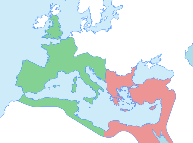
Karte der Grenzen des west- und oströmischen Reichs nach dem Tode Theodosius I. in 395 AD.
Weströmisches Reich
Oströmisches Reich
English:
Map of the boundaries of the western and eastern Roman empires after the death of Theodosius I, in 395 AD.
Western Roman Empire
Eastern Roman Empire
العربية:
خريطة لحدود الإمبراطوريات الرومانية الغربية والشرقية بعد وفاة ثيودوسيوس الأول عام 395م.
الإمبراطورية الرومانية الغربية
الإمبراطورية الرومانية الشرقية
|
| Date | |
| Source |
Own work using: |
| Author | AKIKA3D |
Licensing
I, the copyright holder of this work, hereby publish it under the following license:
This file is licensed under the
Creative Commons
Attribution-Share Alike 4.0 International
license.
-
You are free:
- to share – to copy, distribute and transmit the work
- to remix – to adapt the work
-
Under the following conditions:
- attribution – You must give appropriate credit, provide a link to the license, and indicate if changes were made. You may do so in any reasonable manner, but not in any way that suggests the licensor endorses you or your use.
- share alike – If you remix, transform, or build upon the material, you must distribute your contributions under the same or compatible license as the original.