Wilderness_road_en.png

Size of this preview:
800 × 508 pixels
.
Other resolutions:
320 × 203 pixels
|
640 × 406 pixels
|
1,024 × 650 pixels
|
1,254 × 796 pixels
.
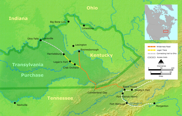
- Description: Course of the Wilderness Road in Kentucky by 2013. Darker green outlines represent the later boundaries of Kentucky, while green shading represents the Transylvania Purchase.
- Source: Own work by Nikater, submitted to the public domain. Background map courtesy of Demis, www.demis.nl.
- Uploader: User:Nikater
- date;14 April 2000
- Other Versions: German Image:Wilderness road_de.png
- License status:
|
|
This image is in the
public domain
because it came from the site
https://www.demis.nl/products/web-map-server/examples/
and was released by the
copyright
holder. Permission is granted to copy, distribute and/or modify this map since it is based on free of copyright images from:
www.demis.nl
. See also
approval email on de.wp
and
its clarification
.
|
|
|
This work has been released into the
public domain
by its
copyright
holder,
www.demis.nl
. This applies worldwide.
In some countries this may not be legally possible; if so: www.demis.nl grants anyone the right to use this work for any purpose , without any conditions, unless such conditions are required by law.
|

|
This
map
image could be re-created
using
vector graphics
as an
SVG
file
. This has several advantages; see
Commons:Media for cleanup
for more information. If an SVG form of this image is available, please upload it and afterwards replace this template with
{{

vector version available

|

new image name

}}
.
It is recommended to name the SVG file “Wilderness road en.svg”—then the template Vector version available (or Vva ) does not need the new image name parameter. |