World_Trade_Center,_NY_-_2001-09-11_-_Debris_Impact_Areas.svg

Size of this PNG preview of this SVG file:
521 × 599 pixels
.
Other resolutions:
209 × 240 pixels
|
417 × 480 pixels
|
668 × 768 pixels
|
891 × 1,024 pixels
|
1,781 × 2,048 pixels
|
2,110 × 2,426 pixels
.
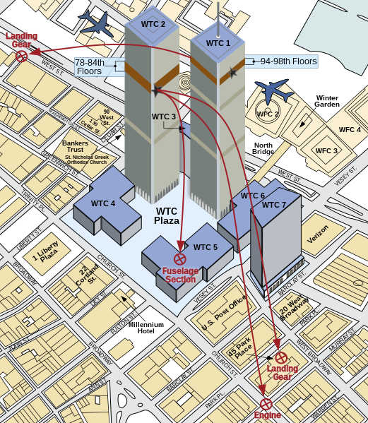
| Description |
English:
A diagram showing the areas where debris from
American Airlines Flight 11
and
United Airlines Flight 175
fell upon
Lower Manhattan
during the course of the
September 11 terror attacks
.
|
||
| Date | |||
| Source | Own work. Derived from 911 - FEMA - Areas debris impact (graphic).png by Therese McAllister, Jonathan Barnett, John Gross, Ronald Hamburger, Jon Magnuson of the Federal Emergency Management Agency (FEMA) of the United States Department of Homeland Security . As a work of the United States government, it was released to the public domain. It can be located on page 6 of this FEMA study . | ||
| Author | Cflm001 ( talk ) | ||
|
Permission
( Reusing this file ) |
I, the copyright holder of this work, hereby publish it under the following licenses:
This file is licensed under the
Creative Commons
Attribution-Share Alike 3.0 Unported
license.
You may select the license of your choice.
|
||
| Other versions |
This file was derived from:
911 - FEMA - Areas debris impact (graphic).png
:
.png)
|
||
| SVG development |
This diagram was created with
Adobe Illustrator
.
This diagram uses
embedded
text that can be
easily translated
using a text editor.
|
