Alberta_Highway_16A
Alberta Highway 16A
Highway in Alberta
Alberta Provincial Highway No. 16A, commonly referred to as Highway 16A, is the designation of three alternate routes off Alberta Highway 16 (the Yellowhead highway) in Alberta, Canada. The Evansburg – Entwistle section is called 16A:08 by Alberta Transportation, while 16A:24 runs through Vegreville. The section west of Edmonton is labelled 16A:14 and 16A:16 on Alberta Transportation maps, but is better known as Parkland Highway and Stony Plain Road.
Segments of Highway 16A in Alberta | ||||
| Route information | ||||
| Auxiliary route of Hwy 16 | ||||
| Maintained by Alberta Transportation | ||||
| Evansburg – Entwistle segment | ||||
| Length | 13.6 km[1] (8.5 mi) | |||
| West end | ||||
| Major intersections | ||||
| East end | ||||
| Parkland Highway | ||||
| Length | 34.8 km[2] (21.6 mi) | |||
| West end | ||||
| Major intersections | ||||
| East end | ||||
| Vegreville segment | ||||
| Length | 9.5 km[3] (5.9 mi) | |||
| West end | ||||
| East end | ||||
| Location | ||||
| Country | Canada | |||
| Province | Alberta | |||
| Specialized and rural municipalities | Yellowhead County, Parkland County, County of Minburn No. 27 | |||
| Major cities | Edmonton, Spruce Grove | |||
| Towns | Stony Plain, Vegreville | |||
| Highway system | ||||
|
| ||||
| ||||
Highway 16A:08 parallels Highway 16 to the north, intersecting Highway 22, and passing through Evansburg, Pembina River Provincial Park, and Entwistle.
Major intersections
Starting from the west end of Highway 16A:[4]
| Rural/specialized municipality | Location | km[1] | mi | Destinations | Notes |
|---|---|---|---|---|---|
| Yellowhead County | | 0.0 | 0.0 | ||
| 2.7 | 1.7 | ||||
| Evansburg | 8.5 | 5.3 | UAR 115 south (Range Road 75) | ||
| ↑ / ↓ | | 9.5 | 5.9 | Crosses the Pembina River | |
| Parkland County | | 9.5– 10.5 | 5.9– 6.5 | Passes through Pembina River Provincial Park | |
| Entwistle | 13.6 | 8.5 | Interchange; Hwy 16 exit 289; continues as Hwy 22 south | ||
| 1.000 mi = 1.609 km; 1.000 km = 0.621 mi | |||||
| Parkland Highway | |
| Length: | 30.5 km (19.0 mi) |
| West end: | |
| East end: | 231 Street, Edmonton |
Running for 35 km (22 mi), the Parkland Highway (Highway 16A) runs parallel to Highway 16, located 3.2 km (2.0 mi) to the north. The highway starts west of Stony Plain, Alberta near the hamlet of Carvel. Parkland Highway is a central thoroughfare through the bedroom communities of Stony Plain and Spruce Grove. At Acheson it intersects with Highway 60. Highway 16A enters Edmonton along Stony Plain Road, splits into one-way streets where eastbound traffic follows 100 Avenue, before ending at Anthony Henday Drive (Highway 216).
Highway 16A and the Parkland Highway were established in 1997 when the Highway 16 designation was moved to Highway 16X,[5] a bypass route that became Yellowhead Trail in Edmonton.
Major intersections
All exits are unnumbered.
| Rural/specialized municipality | Location | km[2] | mi | Destinations | Notes |
|---|---|---|---|---|---|
| Parkland County | | 0.0 | 0.0 | Interchange; Hwy 16 exit 344); eastbound entrance and westbound exit | |
| 5.4 | 3.4 | Parkland Drive (Township Road 530) – Spring Lake | Former Hwy 29 | ||
| Town of Stony Plain | 10.9 | 6.8 | 50 Street | Eastbound right-in/right-out | |
| 11.3 | 7.0 | Partial cloverleaf interchange Fifth Meridian, 114° Longitude | |||
| 12.8 | 8.0 | South Park Drive / North Park Drive | Traffic signals | ||
| 14.1 | 8.8 | Boundary Road / Veterans Boulevard | Traffic signals | ||
| City of Spruce Grove | 15.7 | 9.8 | Jennifer Heil Way / Campsite Road | Traffic signals | |
| 17.3 | 10.7 | Calahoo Road / Golden Spike Road | Traffic signals; former Hwy 788 | ||
| 18.0 | 11.2 | King Street | Traffic signals | ||
| 19.0 | 11.8 | Century Road | Traffic signals | ||
| Parkland County | Acheson | 25.7 | 16.0 | Range Road 264 | Right-in/right-out |
| 27.3 | 17.0 | Partial cloverleaf interchange | |||
| City of Edmonton | 30.5 | 19.0 | 231 Street, Range Road 261 | Edmonton city limits; becomes Stony Plain Road | |
| 32.2 | 20.0 | Winterburn Road (215 Street) | Partial cloverleaf interchange | ||
| 33.4 | 20.8 | One-way transition | |||
| 33.4– 34.8 | 20.8– 21.6 | Cloverstack interchange (Hwy 216 exit 21); Hwy 2 is unsigned; Hwy 16A ends | |||
| Stony Plain Road / 100 Avenue – Downtown Edmonton | Eastbound traffic follows 100 Avenue; westbound traffic follows Stony Plain Road | ||||
| 1.000 mi = 1.609 km; 1.000 km = 0.621 mi | |||||
Highway 16A:24 runs through the Town of Vegreville as 50 Avenue.
Major intersections
Starting from the west end of Highway 16A:[4]
| Location | km[3] | mi | Destinations | Notes | |
|---|---|---|---|---|---|
| County of Minburn No. 27 | 0.0 | 0.0 | Interchange; Hwy 16 exit 481; eastbound exit and westbound entrance | ||
| Vegreville | 5.2 | 3.2 | West end of Hwy 857 concurrency | ||
| 6.3 | 3.9 | 50 Street | |||
| 7.2 | 4.5 | East end of Hwy 857 concurrency | |||
| County of Minburn No. 27 | 9.5 | 5.9 | Interchange Hwy 16 exit 492; westbound exit, eastbound entrance | ||
1.000 mi = 1.609 km; 1.000 km = 0.621 mi
| |||||
Strathcona County
Highway 16A | |
|---|---|
| Location | Strathcona County |
| Length | 7.2 km[6] (4.5 mi) |
| Existed | 1996 |
Highway 16A used to follow Baseline Road (101 Avenue), past Refinery Row, and linked with Highway 16 in Strathcona County. It began at the Edmonton city limits, located approximately 1.1 km (0.68 mi) east of the 50 Street intersection, and traveled east for 3.9 km (2.4 mi) to Highway 14X where it turned north for 3.3 km (2.1 mi) and terminated at Highway 16.[6] In 1996, the province reverted the Baseline Road to Strathcona County while the north–south section became part of Highway 14X.[7] Highway 14X was later renumbered Highway 216 in 1999,[8] and signed as a part of Anthony Henday Drive in 2010.
Downtown Edmonton
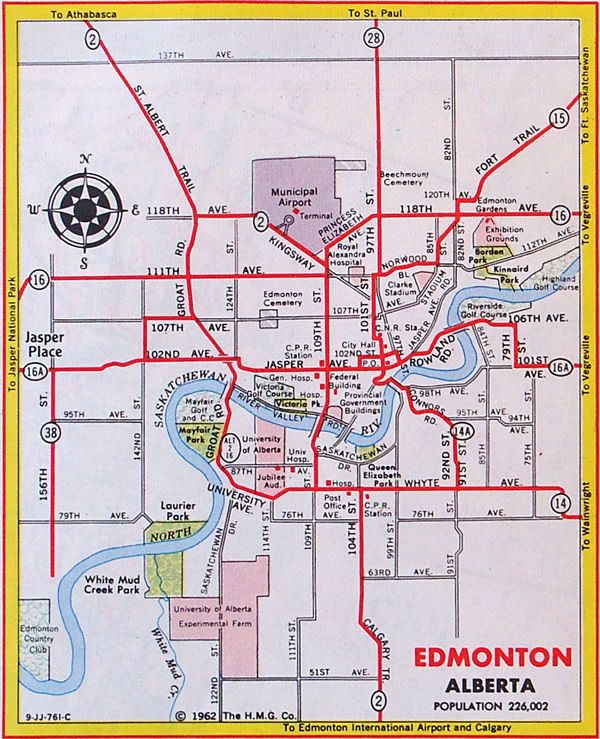
The Strathcona County segment of Highway 16A used to be part of a larger route which passed through central Edmonton, itself an original alignment of Highway 16.[10] At the time, Highway 16 entered west Edmonton along Stony Plain Road and followed Mayfield Road, and Highway 16A originated at the intersection of Highway 16, Stony Plain Road, Mayfield Road. It travelled east along Stony Plain Road and 102 Avenue through the former town of Jasper Place for 5.3 km (3.3 mi) to 124 Street where it turned south for 150 m (490 ft) and then turned east onto Jasper Avenue for 3.9 km (2.4 mi), passing through Downtown Edmonton. At 95 Street, Highway 16A turned south for 170 m (560 ft) before turning east along Rowland Road for 1.7 km (1.1 mi) and crossing the North Saskatchewan River along the Dawson Bridge. East of 84 Street, Highway 16A followed 106 Avenue for 500 m (1,600 ft) to 79 Street (later using 84 Street), where it traveled south 900 m (3,000 ft) before turning east onto 101 Avenue and leaving Edmonton.[9][11]
Highway 16A was phased out in the early 1980s.
- Google (January 10, 2017). "Highway 16A through Evansburg/Entwistle" (Map). Google Maps. Google. Retrieved January 10, 2017.
- Google (January 10, 2017). "Parkland Highway" (Map). Google Maps. Google. Retrieved January 10, 2017.
- Google (January 10, 2017). "Highway 16A through Vegreville" (Map). Google Maps. Google. Retrieved January 10, 2017.
- "2015 Provincial Highway 1-216 Progress Chart" (PDF). Alberta Transportation. March 2015. Archived (PDF) from the original on April 10, 2016. Retrieved October 12, 2016.
- "Highways 16 and 16X Renumbered to Provide Greater Consistency". Government of Alberta. June 4, 1997. Retrieved January 10, 2017.
- Google (January 10, 2017). "Old Highway 16A through Strathcona County" (Map). Google Maps. Google. Retrieved January 10, 2017.
- Alberta Official Road Map (Map). Alberta Environmental Protection, Resource Data Division. 1996. Edmonton inset.
- Alberta Official Road Map (Map). Alberta Environmental Protection, Resource Data Division. 1999. Edmonton inset.
- Google (January 10, 2017). "Old Highway 16A through Edmonton" (Map). Google Maps. Google. Retrieved January 10, 2017.
- Alberta Official Road Map (Map). Department of Public Works. 1940. Edmonton inset.
- Alberta Official Road Map (Map). Government of the Province of Alberta. 1962. Edmonton inset.