Broadway_station_(BMT_Astoria_Line)
Broadway station (BMT Astoria Line)
New York City Subway station in Queens
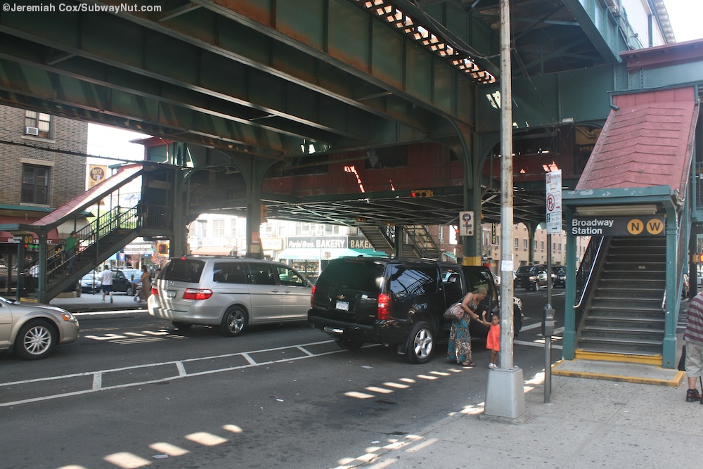
The Broadway station is a local station on the BMT Astoria Line of the New York City Subway. It is located above 31st Street at Broadway in Astoria, Queens. The station is served by the N train at all times, as well as by the W train on weekdays.
Broadway | ||||||||||||||||||||||||||||||||||||||||||||||||||||||||||||||||||||
|---|---|---|---|---|---|---|---|---|---|---|---|---|---|---|---|---|---|---|---|---|---|---|---|---|---|---|---|---|---|---|---|---|---|---|---|---|---|---|---|---|---|---|---|---|---|---|---|---|---|---|---|---|---|---|---|---|---|---|---|---|---|---|---|---|---|---|---|---|
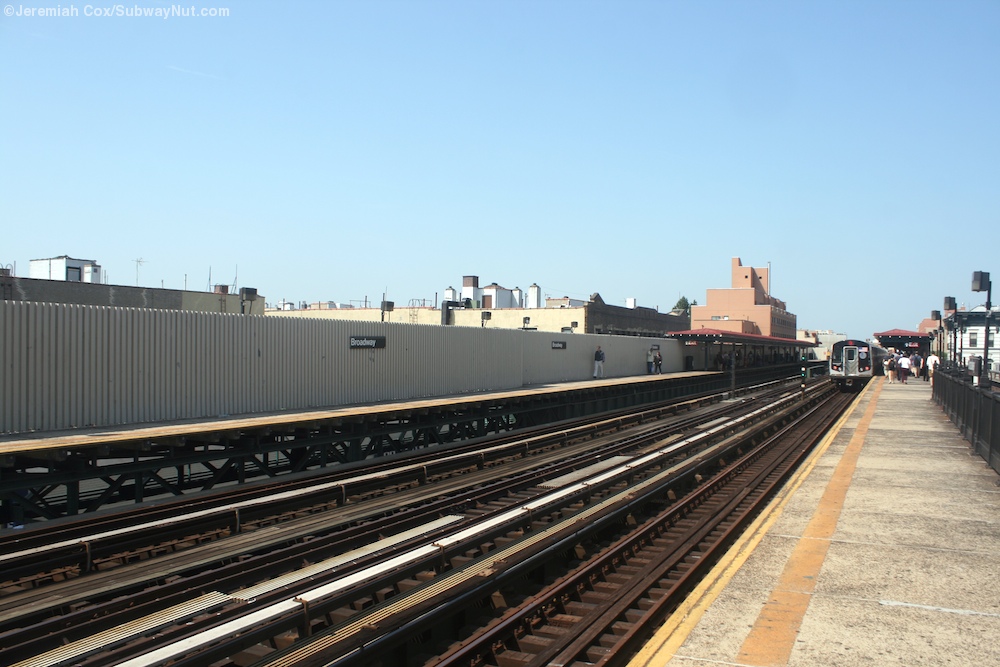
 View of the renovated station from the southbound platform | ||||||||||||||||||||||||||||||||||||||||||||||||||||||||||||||||||||
| Station statistics | ||||||||||||||||||||||||||||||||||||||||||||||||||||||||||||||||||||
| Address | Broadway & 31st Street Astoria, NY 11106 | |||||||||||||||||||||||||||||||||||||||||||||||||||||||||||||||||||
| Borough | Queens | |||||||||||||||||||||||||||||||||||||||||||||||||||||||||||||||||||
| Locale | Astoria | |||||||||||||||||||||||||||||||||||||||||||||||||||||||||||||||||||
| Coordinates | 40.761951°N 73.925414°W / 40.761951; -73.925414 | |||||||||||||||||||||||||||||||||||||||||||||||||||||||||||||||||||
| Division | B (BMT)[1] | |||||||||||||||||||||||||||||||||||||||||||||||||||||||||||||||||||
| Line | BMT Astoria Line | |||||||||||||||||||||||||||||||||||||||||||||||||||||||||||||||||||
| Services | N W | |||||||||||||||||||||||||||||||||||||||||||||||||||||||||||||||||||
| Transit | ||||||||||||||||||||||||||||||||||||||||||||||||||||||||||||||||||||
| Structure | Elevated | |||||||||||||||||||||||||||||||||||||||||||||||||||||||||||||||||||
| Platforms | 2 side platforms | |||||||||||||||||||||||||||||||||||||||||||||||||||||||||||||||||||
| Tracks | 3 (2 in regular service) | |||||||||||||||||||||||||||||||||||||||||||||||||||||||||||||||||||
| Other information | ||||||||||||||||||||||||||||||||||||||||||||||||||||||||||||||||||||
| Opened | February 1, 1917; 107 years ago (1917-02-01) | |||||||||||||||||||||||||||||||||||||||||||||||||||||||||||||||||||
| Closed | July 2, 2018; 5 years ago (2018-07-02) (reconstruction) | |||||||||||||||||||||||||||||||||||||||||||||||||||||||||||||||||||
| Rebuilt | January 24, 2019; 5 years ago (2019-01-24) | |||||||||||||||||||||||||||||||||||||||||||||||||||||||||||||||||||
| Accessible | not ADA-accessible; accessibility planned | |||||||||||||||||||||||||||||||||||||||||||||||||||||||||||||||||||
| Opposite- direction transfer | Yes | |||||||||||||||||||||||||||||||||||||||||||||||||||||||||||||||||||
| Traffic | ||||||||||||||||||||||||||||||||||||||||||||||||||||||||||||||||||||
| 2023 | 2,763,230[2] | |||||||||||||||||||||||||||||||||||||||||||||||||||||||||||||||||||
| Rank | 118 out of 423[2] | |||||||||||||||||||||||||||||||||||||||||||||||||||||||||||||||||||
| ||||||||||||||||||||||||||||||||||||||||||||||||||||||||||||||||||||
| ||||||||||||||||||||||||||||||||||||||||||||||||||||||||||||||||||||
| ||||||||||||||||||||||||||||||||||||||||||||||||||||||||||||||||||||
| ||||||||||||||||||||||||||||||||||||||||||||||||||||||||||||||||||||
| ||||||||||||||||||||||||||||||||||||||||||||||||||||||||||||||||||||


This station opened on February 1, 1917, along with the rest of the Astoria Line, which was originally part of the IRT, as a spur off the IRT Queensboro Line, which is now the IRT Flushing Line. Trains ran between Grand Central and Astoria.[3][4] On July 23, 1917, the Queensboro Bridge spur of the elevated IRT Second Avenue Line opened. At that time, all elevated trains to Queensboro Plaza used the Astoria Line while all subway trains used the IRT Flushing Line, though this was later changed with trains alternating between branches.[4][5] This station started to be served by BMT shuttles using elevated cars on April 8, 1923.[6]
The city government took over the BMT's operations on June 1, 1940,[7][8] and the IRT's operations on June 12, 1940.[9][10] On October 17, 1949, the Astoria Line became BMT-only as the tracks at Queensboro Plaza were consolidated and the platforms on the Astoria Line were shaved back to allow BMT trains to operate on it. Service was initially provided by the Brighton Local (BMT 1) and the Broadway–Fourth Avenue Local (BMT 2) at all times.[11]
Station renovations
The platforms at this station, along with six others on the Astoria Line, were lengthened to 610 feet (190 m) to accommodate ten-car trains in 1950.[12]: 23 The project cost $863,000. Signals on the line had to be modified to take the platform extensions into account.[13]: 633, 729
.jpg)
Under the 2015–2019 MTA Capital Plan, the station underwent a complete overhaul as part of the Enhanced Station Initiative and was entirely closed for several months. Updates included cellular service, Wi-Fi, USB charging stations, interactive service advisories and maps.[14][15] The award for Package 2 of the renovations, which covered renovations at the 30th Avenue, Broadway, 36th Avenue, and 39th Avenue stations, was awarded on April 14, 2017, to Skanska USA.[16] The Broadway and 39th Avenue stations were closed entirely on July 2, 2018, and reopened on January 24, 2019, slightly earlier than expected.[17] A previously demolished entrance to the northeast corner of Broadway and 31st Street was added once again to improve access.[18]
In 2018 the MTA installed hand-painted laminated glass murals in the elevated walkway. The artwork, Outlook, was created by Diane Carr and fabricated by Peters Studios / Glasmalerei Peters.[19][20][21]
In 2019, the MTA announced that this station would become ADA-accessible as part of the agency's 2020–2024 Capital Program.[22] A contract for two elevators at the station was awarded in December 2023.[23]
| Platforms | Side platform, doors will open on the right | |
| Southbound local | ← ← | |
| Peak-direction express | ← No regular service | |
| Northbound local | → | |
| Side platform, doors will open on the right | ||
| Mezzanine | To entrances/exits, station agent, MetroCard vending machines | |
| Ground | Street level | Entrances/exits |
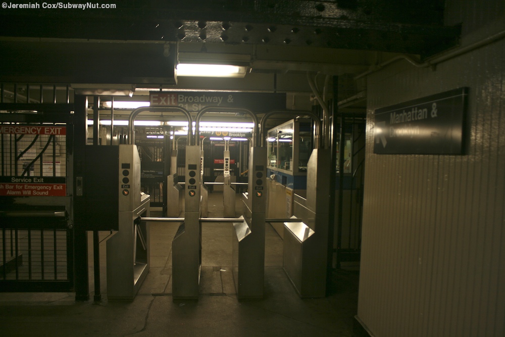
This station has two side platforms and three tracks. The center track is not used in revenue service, but it had been used regularly as recently as 2002.[24] The station contains wooden canopies with transite and wooden mezzanines, but only the southbound platform has windscreens.[25] The station has a narrow crossover in its mezzanine that allows for passengers to change their direction of travel at the station.[26]
Exits
The mezzanine is configured like 30th Avenue. Outside of fare control, street stairs descend to all corners of Broadway and 31st Street.[27][28] An exit-only stair from the northbound platform descends to the east side of 31st Street between Broadway and 34th Avenue.[29]
- "Glossary". Second Avenue Subway Supplemental Draft Environmental Impact Statement (SDEIS) (PDF). Vol. 1. Metropolitan Transportation Authority. March 4, 2003. pp. 1–2. Archived from the original (PDF) on February 26, 2021. Retrieved January 1, 2021.
- "Annual Subway Ridership (2018–2023)". Metropolitan Transportation Authority. 2023. Retrieved April 20, 2024.
- "First Train Runs On Elevated Line to Astoria Section". Brooklyn Daily Eagle. February 1, 1917. Retrieved June 29, 2015 – via Newspapers.com.
- Annual report. 1916-1917. New York: Interborough Rapid Transit Company. 1917. pp. 15–16 – via HathiTrust.
- "Subway Link Over Queensboro Bridge". The New York Times. July 22, 1917. p. 31. Retrieved December 18, 2011.
- "Additional Subway Service to Borough of Queens". The New York Times. April 8, 1923. p. RE1. Retrieved December 18, 2011.
- "B.M.T. Lines Pass to City Ownership; $175,000,000 Deal Completed at City Hall Ceremony-- Mayor 'Motorman No. 1'". The New York Times. June 2, 1940. ISSN 0362-4331. Archived from the original on July 19, 2021. Retrieved May 14, 2022.
- "City Takes Over B. M. T. System; Mayor Skippers Midnight Train". New York Herald Tribune. June 2, 1940. p. 1. ProQuest 1243059209.
- "City Transit Unity Is Now a Reality; Title to I.R.T. Lines Passes to Municipality, Ending 19-Year Campaign". The New York Times. June 13, 1940. ISSN 0362-4331. Archived from the original on January 7, 2022. Retrieved May 14, 2022.
- "Transit Unification Completed As City Takes Over I. R. T. Lines: Systems Come Under Single Control After Efforts Begun in 1921; Mayor Is Jubilant at City Hall Ceremony Recalling 1904 Celebration". New York Herald Tribune. June 13, 1940. p. 25. ProQuest 1248134780.
- "Direct Subway Runs to Flushing, Astoria". The New York Times. October 15, 1949. p. 17. Retrieved December 18, 2011.
- Board of Transportation of the City of New York (1950). Proceedings of the Board of Transportation of the City of New York. New York.
{{cite book}}: CS1 maint: location missing publisher (link) - Whitford, Emma (January 8, 2016). "MTA Will Completely Close 30 Subway Stations For Months-Long "Revamp"". Gothamist. Archived from the original on March 23, 2020. Retrieved July 18, 2016.
- "MTA Stations" (PDF). governor.ny.gov. Government of the State of New York. Archived (PDF) from the original on November 2, 2019. Retrieved July 18, 2016.
- Capital Program Oversight Committee Meeting (PDF). mta.info (Report). Metropolitan Transportation Authority. April 24, 2017. p. 17. Archived (PDF) from the original on August 20, 2020. Retrieved April 24, 2017.
- "Broadway and 39 Av stations will temporarily close for extensive renovation All times beginning 5 AM, July 2, until February 2019". web.mta.info. Metropolitan Transportation Authority. June 2018. Retrieved June 18, 2018.
- "Broadway & 39 Av NW Stations to Undergo Extensive Repairs & Renovations". www.mta.info. Metropolitan Transportation Authority. June 8, 2018. Archived from the original on June 12, 2018. Retrieved June 8, 2018.
- "Artwork: "Outlook" (Diane Carr)". www.nycsubway.org. Retrieved March 22, 2024.
- "Press Release - MTA Headquarters - MTA Announces 20 Additional Subway Stations to Receive Accessibility Improvements Under Proposed 2020-2024 Capital Plan". MTA. December 19, 2019. Archived from the original on April 21, 2020. Retrieved December 20, 2019.
- Dougherty, Peter (2006) [2002]. Tracks of the New York City Subway 2006 (3rd ed.). Dougherty. OCLC 49777633 – via Google Books.
- Cox, Jeremiah (May 26, 2010). "Looking across to the narrow end of the windscreened Manhattan-bound platform". subwaynut.com. Retrieved August 8, 2017.
- Cox, Jeremiah (May 26, 2010). "Approaching the turnstiles from the Astoria-bound side, notice the sign for the narrow fenced in passageway to crossunder and change direction". subwaynut.com. Retrieved August 8, 2017.
- "MTA Neighborhood Maps: Astoria" (PDF). Metropolitan Transportation Authority. 2015. Retrieved September 27, 2015.
- Cox, Jeremiah (August 5, 2009). "A street level view of Broadway Station". subwaynut.com. Archived from the original on August 9, 2017. Retrieved August 8, 2017.
- "Capital Program Oversight Committee Meeting" (PDF). Metropolitan Transportation Authority. November 13, 2017. p. 25. Retrieved November 19, 2017.
 Media related to Broadway (BMT Astoria Line) at Wikimedia Commons
- nycsubway.org – BMT Astoria Line: Broadway
- Station Reporter — N Train
- Broadway entrance from Google Maps Street View
- Platforms from Google Maps Street View