Eungella,_Queensland
Eungella, Queensland
Town in Queensland, Australia
Eungella is a rural town and locality in the Mackay Region, Queensland, Australia.[2][3] In the 2016 census, Eungella had a population of 194 people.[1]
Download coordinates as:
| Eungella Queensland | |||||||||||||||
|---|---|---|---|---|---|---|---|---|---|---|---|---|---|---|---|
Eungella, Queensland, Australia, in the clouds at the top of the range, 2021 | |||||||||||||||
| Coordinates | 21.1305°S 148.4922°E / -21.1305; 148.4922 (Eungella (town centre)) | ||||||||||||||
| Population | 194 (2016 census)[1] | ||||||||||||||
| • Density | 4.575/km2 (11.85/sq mi) | ||||||||||||||
| Postcode(s) | 4757 | ||||||||||||||
| Elevation | 690 m (2,264 ft) | ||||||||||||||
| Area | 42.4 km2 (16.4 sq mi) | ||||||||||||||
| Time zone | AEST (UTC+10:00) | ||||||||||||||
| Location | |||||||||||||||
| LGA(s) | Mackay Region | ||||||||||||||
| State electorate(s) | Mirani | ||||||||||||||
| Federal division(s) | Capricornia | ||||||||||||||
| |||||||||||||||
.jpg)
The town of Eungella sits at the top of the escarpment of the Clarke Range at 690 metres (2,260 ft) above sea level, falling to an elevation of 200 metres (660 ft) in Netherdale to the immediate east. The southern branch of Cattle Creek forms on this escarpment and creates the fertile valley to the east, where it becomes a tributary of the Pioneer River in Mirani, which eventually flows into the Coral Sea at Mackay.[4]
The escarpment and several other parts of the locality are within the Eungella National Park, which extends into the neighbouring localities of Netherdale and Broken River and beyond. In the west and south of the locality are parts of the Crediton Forest Reserve which extends into the neighbouring localities of Crediton and Eungella Dam. There is also a section of the Crediton State Forest within the locality with another section in Crediton.[4]
Due to the mountainous terrain and the protected areas, there is limited development of the land in the locality. Apart from residential use, the remaining land use is for grazing on native vegetation.[4]
The town takes its name from a pastoral run named by explorer and pioneer Ernest Favenc in July 1876. The name is believed to be an Aboriginal word meaning land of cloud.[3]
The locality was within the proclaimed boundaries of the Eungella Goldfield at the end of the 1800s and early 1900s. Access to the area was by a pack horse track or by a road via Nebo and Mount Britton.[5][6] The Eungella Range Road opened in 1909.[7] However damage had been incurred within twelve months, and repairs and a deviation instigated.[8] In 1923 the first car traveled on the Eungella Range in wet slippery conditions, and resorted to tying a heavy sapling behind the car to steady the car.[9] Landslips continue to be an issue following heavy rain.[10]
Eungella Provisional School opened on circa 1891 but closed circa 1899.[11]
On 31 January 1928, another Eungella Provisional School was opened and later became Eungella State School.[11][12]
The Eungella Post Office was opened in 1930, but had to change its name due to another post office with the same name in New South Wales. After twelve months of community consultation the name Dalrymple Heights Post Office, after the nearby Mount Dalrymple, was found acceptable by the Postmaster General's Department.[13][14][15][16]
Eungella was a cool retreat from the heat and humidity of the coast for picnic parties and tourists, and a venue for dances.[17] Nineteen families from the region invested in a syndicate to build and operate the Eungella Chalet which was opened in 1933.[18]
The foundation stone of the Eungella Presbyterian Church was laid in July 1947 and it was officially opened on 23 November 1947. The church was designed to be a replica of Reverend Maitland's father's church in Victoria. The church was damaged in March 2010 in Cyclone Ului and again in February 2011 in Cyclone Yasi. The church was demolished in April 2011.[19]
In the 2016 census, Eungella had a population of 194 people.[1]
Eungella State School is a government primary (Prep-6) school for boys and girls at 36 Eungella Dam Road (21.1344°S 148.4912°E / -21.1344; 148.4912 (Eungella State School)).[20][21] In 2018, the school had an enrolment of 38 students with 3 teachers (2 full-time equivalent) and 9 non-teaching staff (4 full-time equivalent).[22]
There is no secondary school in Eungella. The nearest secondary school is Mirani State High School in Mirani to the east.[4]
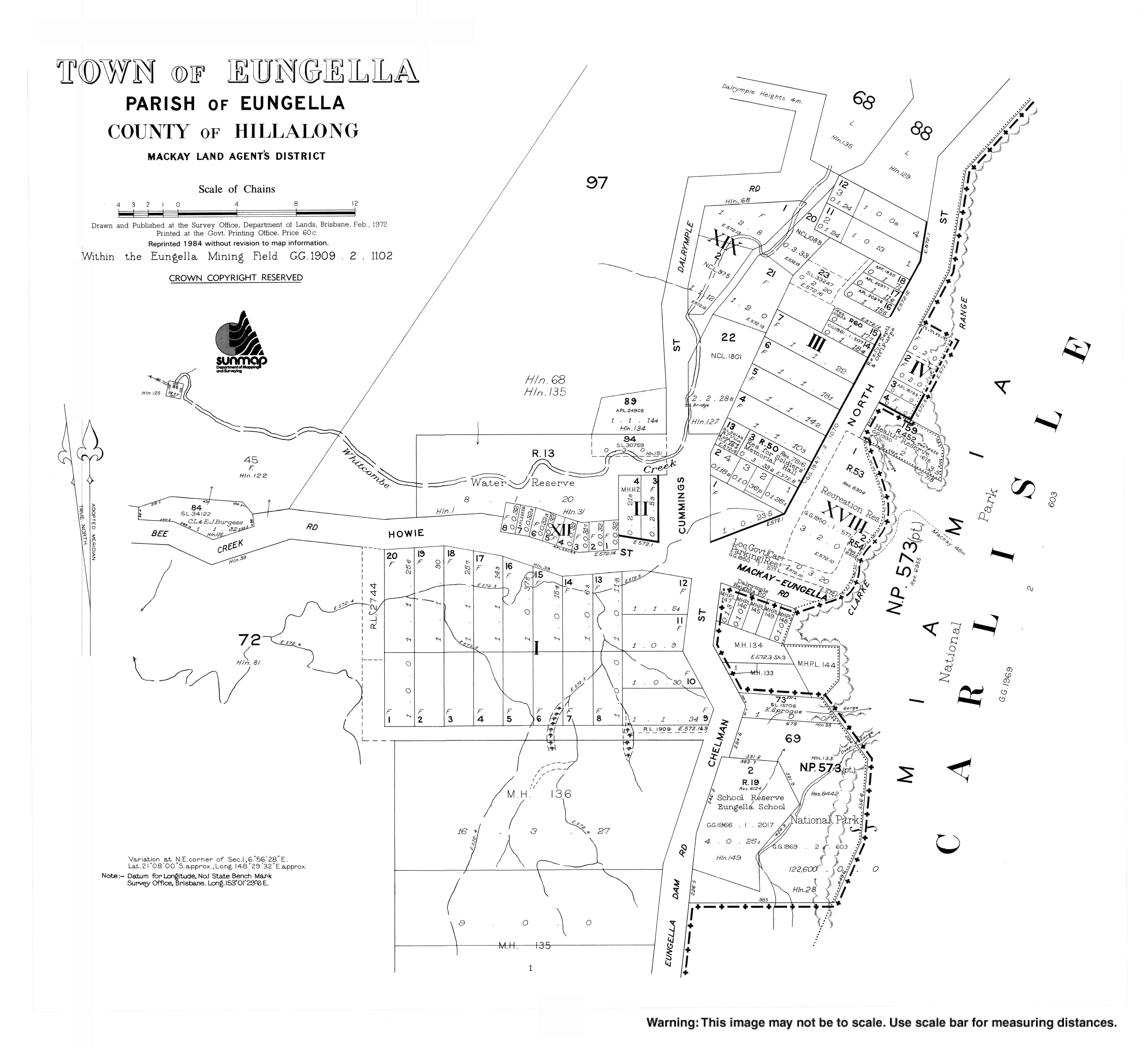
Eungella Memorial Hall is at 13 North Street (21.1303°S 148.4931°E / -21.1303; 148.4931 (Eungella Memorial Hall)).[23] It is also known as the Eungella Hub and is managed by the Eungella District Community Association.[24]
The Eungella Uniting Church is part of the Pioneer Valley Uniting Church. The Eungella congregation meet at the Eungella Memorial Hall.[25][26]
The Eungella Markets are held on the first Sunday morning of every month at the Eungella Memorial Hall.[23]
Eungella National Park is a popular attraction and is noted for rain forest walking trails and sightings of platypus.[27][28] There are also a number of lookouts from the escarpment down the valley, including Goodes Lookout (21.1316°S 148.4936°E / -21.1316; 148.4936 (Goodes Lookout)) in the town and Sky Window lookout (21.1456°S 148.4990°E / -21.1456; 148.4990 (Sky Window Lookout)) in the national park.
- Australian Bureau of Statistics (27 June 2017). "Eungella (SSC)". 2016 Census QuickStats. Retrieved 20 October 2018.

- "Eungella – town in Mackay Region (entry 11952)". Queensland Place Names. Queensland Government. Retrieved 18 September 2020.
- "Eungella – locality in Mackay Region (entry 46782)". Queensland Place Names. Queensland Government. Retrieved 18 September 2020.
- "Queensland Globe". State of Queensland. Retrieved 27 October 2020.
- Parish, Glenda (2011–2013). "Range Road 1908" (PDF). The Eungella Regulla Via Step Back in Time - Gathering Eungella's Past. 24 (4): 1. Archived (PDF) from the original on 19 October 2022. Retrieved 3 February 2023 – via eungella.com.au.
- Ball B.E., Lionel C. (1910) [1910]. "Some Mineral Fields in the Hinterland of Mackay: EUNGELLA GOLDFIELD" (PDF). University of Queensland (Queensland Geological Surveÿ, Publication No. 229). Brisbane: Queensland Government Department of Mines. pp. 25–37. Retrieved 3 February 2023.
- "PUBLIC ESTATE". The Week. Vol. LXVIII, no. 1, 759. Queensland, Australia. 10 September 1909. p. 28. Archived from the original on 5 February 2023. Retrieved 3 February 2023 – via National Library of Australia.
- "THE EUNGELLA RANGE ROAD". Daily Mercury. No. 1540. Queensland, Australia. 8 September 1910. p. 6. Archived from the original on 5 February 2023. Retrieved 3 February 2023 – via National Library of Australia.
- "EUNGELLA TABLELAND". Daily Mercury. Vol. 57, no. 631. Queensland, Australia. 15 May 1923. p. 7. Archived from the original on 5 February 2023. Retrieved 3 February 2023 – via National Library of Australia.
- "Mountain community isolated by landslips waiting for emergency supplies". ABC News. 19 January 2023. Archived from the original on 3 February 2023. Retrieved 3 February 2023.
- Queensland Family History Society (2010), Queensland schools past and present (Version 1.01 ed.), Queensland Family History Society, ISBN 978-1-921171-26-0
- "DISTRICT NEWS". Daily Mercury. Vol. 64, no. 231. Queensland, Australia. 30 September 1930. p. 8. Archived from the original on 5 February 2023. Retrieved 3 February 2023 – via National Library of Australia.
- "EUNGELLA". Daily Mercury. Vol. 65, no. 128. Queensland, Australia. 30 May 1931. p. 14. Retrieved 3 February 2023 – via National Library of Australia.
- "DISTRICT NEWS". Daily Mercury. Vol. 65, no. 24. Queensland, Australia. 28 January 1931. p. 10. Archived from the original on 5 February 2023. Retrieved 3 February 2023 – via National Library of Australia.
- "DISTRICT NEWS". Daily Mercury. Vol. 65, no. 200. Queensland, Australia. 22 August 1931. p. 12. Archived from the original on 5 February 2023. Retrieved 3 February 2023 – via National Library of Australia.
- "Eungella Revisited". Daily Mercury. Vol. 57, no. 663. Queensland, Australia. 25 June 1923. p. 3. Archived from the original on 5 February 2023. Retrieved 3 February 2023 – via National Library of Australia.
- "Eungella Chalet". Daily Mercury. Vol. 67, no. 180. Queensland, Australia. 1 August 1933. p. 8. Archived from the original on 5 February 2023. Retrieved 3 February 2023 – via National Library of Australia.
- "Memories of Eungella's Presbyterian Church" (PDF). Archived (PDF) from the original on 4 March 2020. Retrieved 28 October 2020.
- "State and non-state school details". Queensland Government. 9 July 2018. Archived from the original on 21 November 2018. Retrieved 21 November 2018.
- "Eungella State School". Eungella State School. 29 November 2020. Archived from the original on 22 February 2023. Retrieved 7 September 2023.
- "ACARA School Profile 2018". Australian Curriculum, Assessment and Reporting Authority. Archived from the original on 27 August 2020. Retrieved 28 January 2020.
- "Welcome to Eungella" (PDF). Archived (PDF) from the original on 10 March 2020. Retrieved 28 October 2020.
- "Eungella Hub". www.eungella.com.au. Archived from the original on 29 September 2021. Retrieved 29 September 2021.
- "Find a Church". Uniting Church in Australia, Queensland Synod. Archived from the original on 24 October 2020. Retrieved 22 November 2020.
- "Pioneer Valley Uniting Church". Archived from the original on 29 September 2021. Retrieved 29 September 2021.
- "Platypus Viewing at Broken River". Mackay Region Visitor Information Centre. Archived from the original on 28 October 2020. Retrieved 28 October 2020.
- "Platypus". eungella.com.au. Archived from the original on 19 October 2022. Retrieved 3 February 2023.