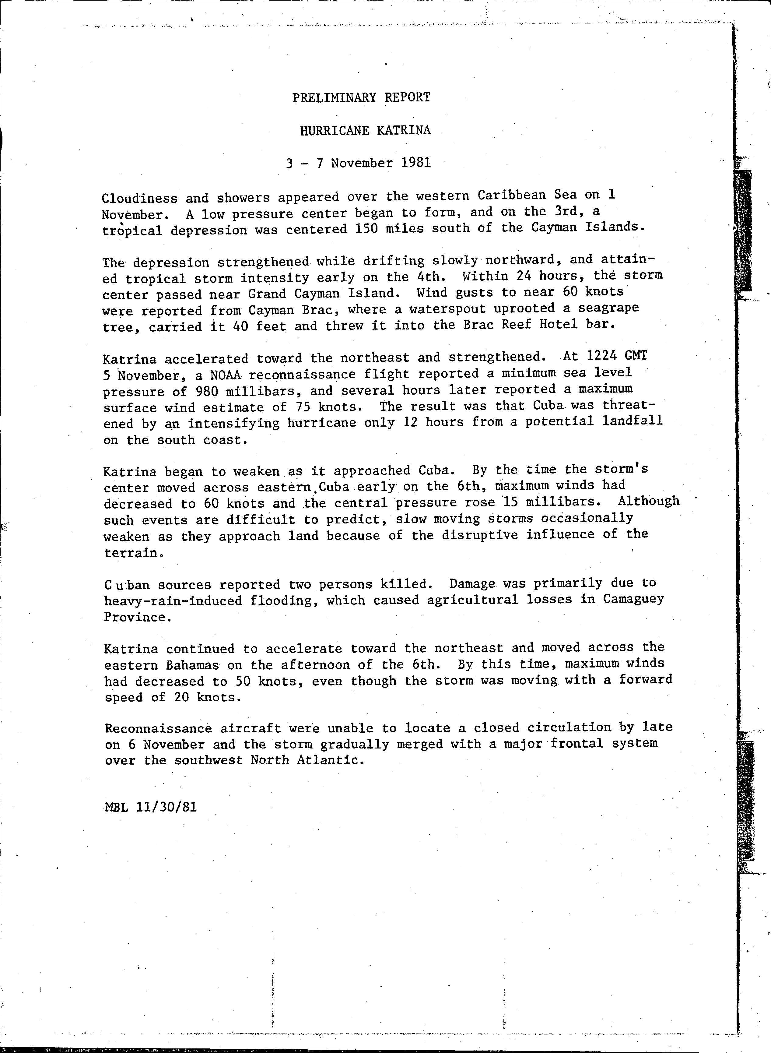
Hurricane Katrina was a late-forming tropical cyclone that impacted portions of the Greater Antilles and Bahamas in November1981. The twenty-first tropical cyclone, eleventh named storm, and seventh hurricane of the 1981 Atlantic hurricane season, Katrina developed from an area of cloudiness in the western Caribbean Sea early on November3. The initial tropical depression deepened slowly, and was upgraded to Tropical Storm Katrina on November5. About six hours later, Katrina peaked with sustained winds of 85mph (140km/h). The storm made landfall along the south coast of Camagüey Province in Cuba early on November6. Katrina quickly weakened to a tropical storm, before emerging into the Atlantic Ocean hours later. The system then accelerated northeastward and crossed the Bahamas late on November6. Katrina dissipated late on November7, shortly before merging with a frontal system.
Quick Facts Meteorological history, Formed ...
Hurricane Katrina
Hurricane Katrina shortly after peak intensity near landfall in Cuba on November 5
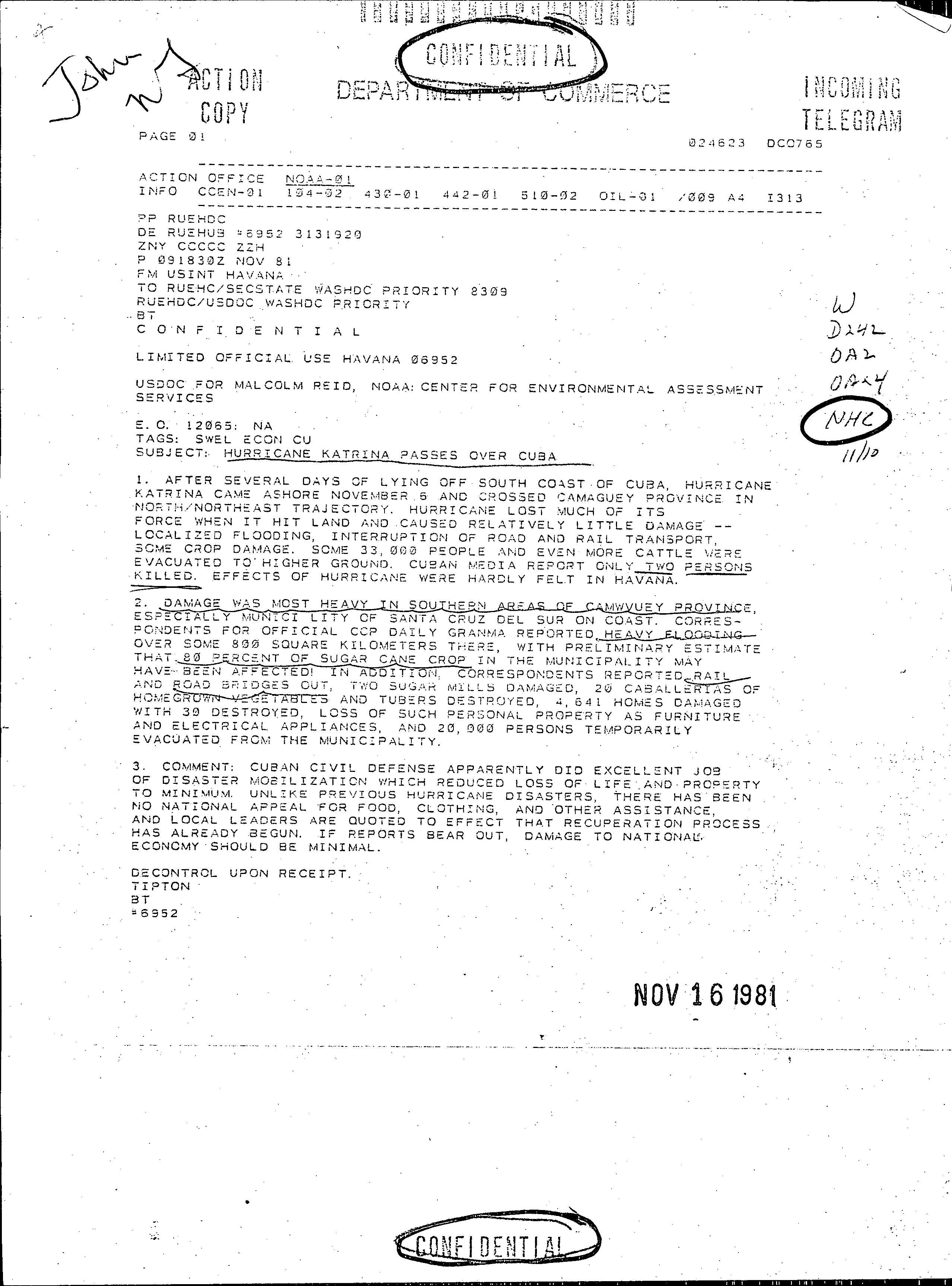
On Grand Cayman, a waterspout ripped out a grape tree and slammed it into the Brac Reef Hotel's bar. Heavy rainfall was observed on Cuba, peaking at 15.74 inches (400mm). As a result, Cuba experienced flash flooding in mountainous areas as Katrina moved across the country. In southern Camagüey Province, several bridges and railroads were reportedly washed out. Two sugar mills suffered damage. An estimated 4,641homes suffered impact, 39of which were destroyed. In addition, approximately 80% of sugar cane crops were damaged. Two people drowned in Cuba while attempting to cross a swollen river in Camagüey Province. The Bahamas received up to 14in (360mm) of rain, causing flood damage to watermelon, tomato and corn crops, particularly on Long Island.
Meteorological history
Map plotting the storm's track and intensity, according to the Saffir–Simpson scale
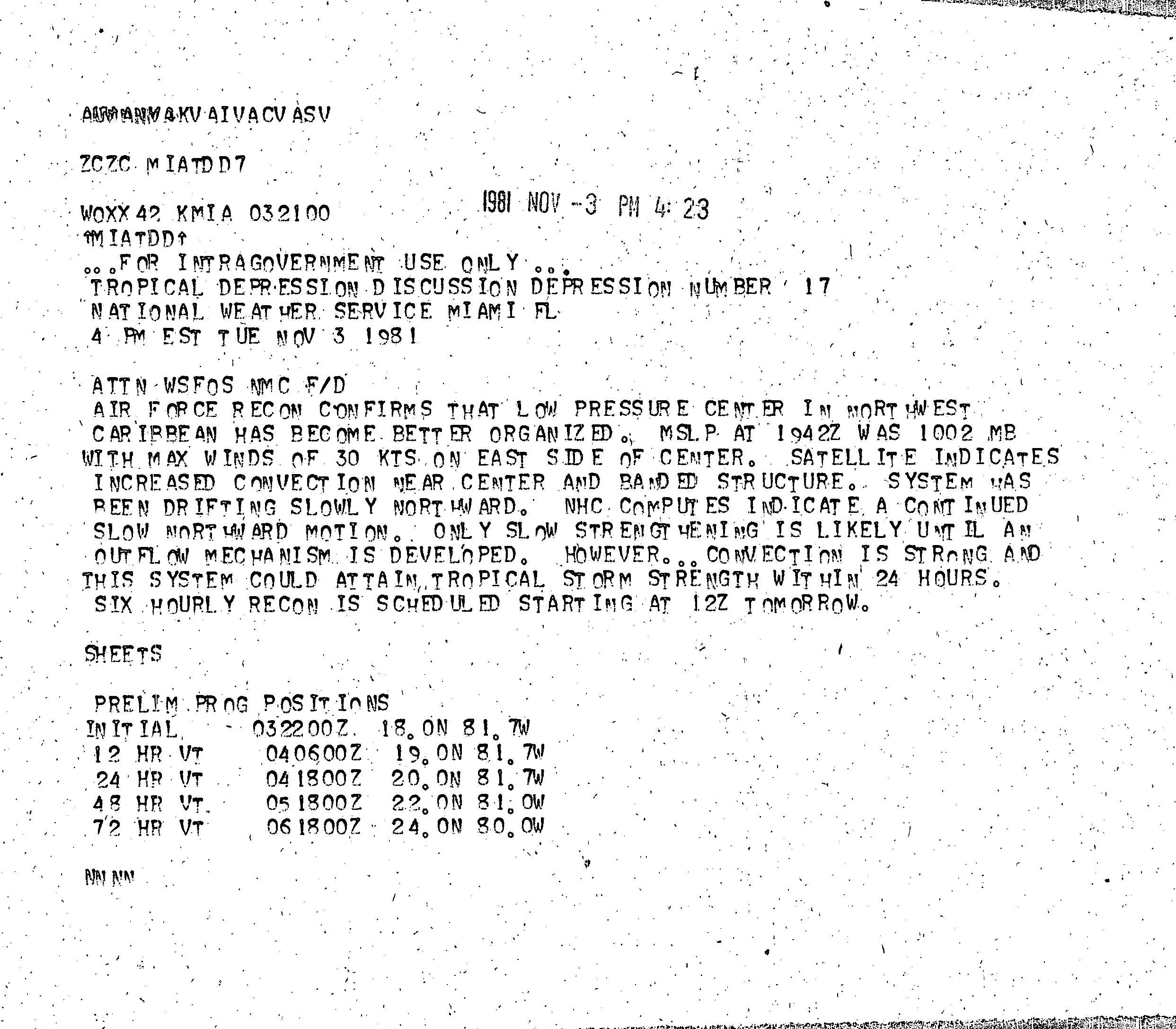
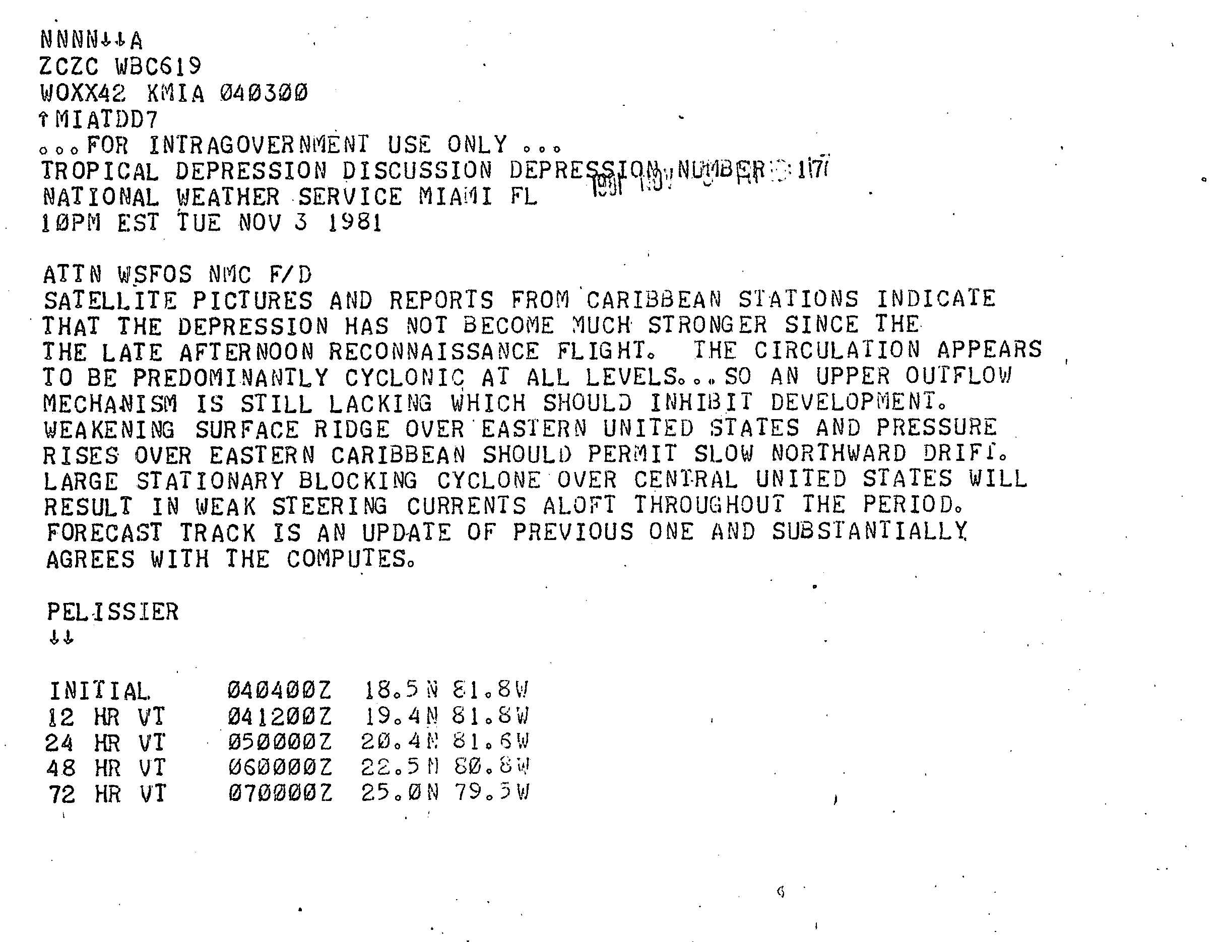
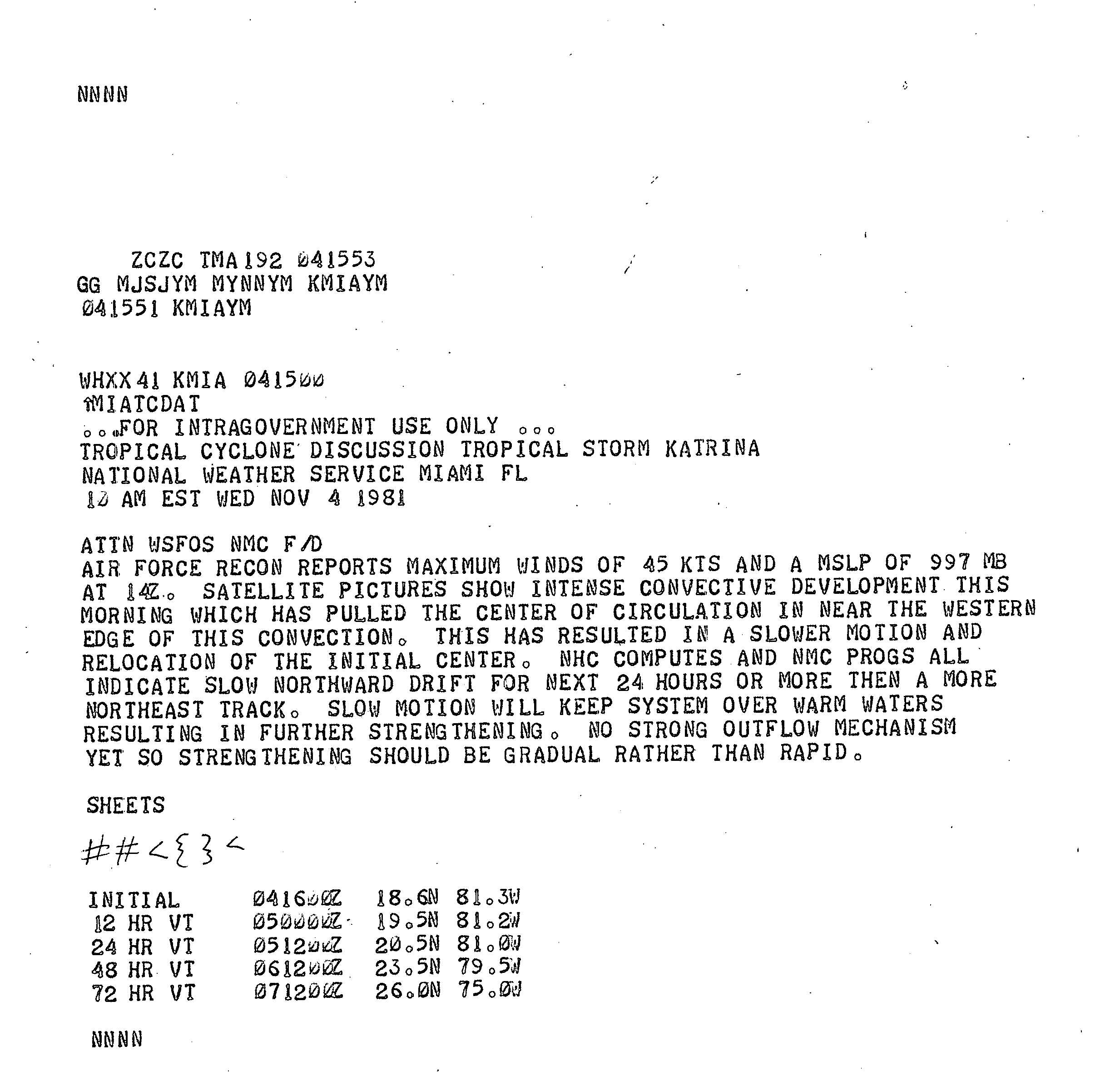
On November 1, an area of disturbed weather– a mass of cloudiness and thunderstorms– developed over the western Caribbean Sea. Subsequently, a low pressure area began to form. The system was designated a tropical depression early on November3, while located about 150 miles (240km) to the south of the Cayman Islands.[1] Operationally, the National Hurricane Center began issuing advisories on the tropical depression at 2200UTC on November3. In the initial advisory, it was noted that the depression would slowly strengthen, but reach tropical storm status within 24hours due to "strong" convection.[2] The depression remained disorganized through early on November4, with satellite imagery and weather stations in the Caribbean Sea region indicating no intensification.[3] However, only a few hours later, the depression strengthened into Tropical Storm Katrina, while drifting northward.[4]
Continuing to strengthen, Katrina slowly recurved north-northeastward and eventually to the northeast.[4] The National Hurricane Center operationally classified Katrina as a tropical depression until 1600UTC on November4, after a reconnaissance aircraft flight reported tropical storm force winds.[5] At 0600UTC on November5, the storm strengthened into a Category1 hurricane on the Saffir–Simpson hurricane wind scale.[4] Later that same day, Katrina attained its peak intensity after another reconnaissance aircraft flight reported a minimum barometric pressure of 980mbar (29inHg), and observed maximum sustained winds of about 85mph (140km/h) on the surface.[1] However, Katrina weakened slightly while approaching Cuba. Early on November6, the storm made landfall in Camagüey Province with winds of 75mph (120km/h). Shortly after moving inland, the system weakened to a tropical storm.[4] A deepening trough offshore the East Coast of the United States caused Katrina to accelerate east-northeastward.[6] By 1330UTC on November6, the storm emerged into the Atlantic Ocean.[7] Katrina slowly weakened while crossing through the central Bahamas later that day. After a reconnaissance aircraft flight failed to locate a closed circulation, the system dissipated late on November7, while located about 380 miles (610km) south-southeast of Bermuda.[4]
Preparations and impact
Hurricane Katrina on November 6, 1981
In anticipation of Katrina, 150,000people and 120,000head of cattle in central Cuba were evacuated, according to a broadcast by Havana radio.[8] As a result, Cuban Civil Defense officers issued a storm alert for five provinces.[9] A hurricane watch was declared for the central and eastern Bahamas, leading to the evacuation of approximately 62,000people.[10] Along the southeast coast of Florida, small craft were advised to remain close to port. However, the storm was not expected to, and did not, pose a threat to the United States.[11][4]
Throughout the Cayman Islands, Katrina dropped up to 12 inches (300mm) of precipitation.[8] In Grand Cayman, a waterspout ripped out a grape tree and slammed it into the Brac Reef Hotel's Bar.[4] The highest observed 24-hour precipitation total in Cuba was 13.03 inches (331mm), while rainfall in the nation peaked at 15.74 inches (400mm).[12] As a result, Cuba experienced flash flooding in mountainous areas as Katrina moved across the country.[13] In southern Camagüey Province, a number of bridges and railroads were washed out. Two sugar mills suffered damage. About 4,641homes suffered impact, 39of which were destroyed. In addition, an estimated 80% of sugar cane crops were damaged.[14] Two people drowned in Cuba while attempting to cross a swollen river in Camagüey Province.[8] The Bahamas received up to 14in (360mm) of rain. Although no deaths or injuries were reported there, heavy rains in the central islands caused flood damage to watermelon, tomato and corn crops on Long Island.[15] Bad weather from Hurricane Katrina caused the cancellation of the 15th running of the Benson and Hedges Gold Cup Race.[16]
Miles B. Lawrence (November 30, 1981). Hurricane Katrina Preliminary Report. National Hurricane Center (Report). National Oceanic and Atmospheric Administration. Retrieved December 3, 2013.
Robert C. Sheets (November 4, 1981). Tropical Cyclone Discussion Tropical Storm Katrina. National Hurricane Center (Report). National Oceanic and Atmospheric Administration. Retrieved December 4, 2013.
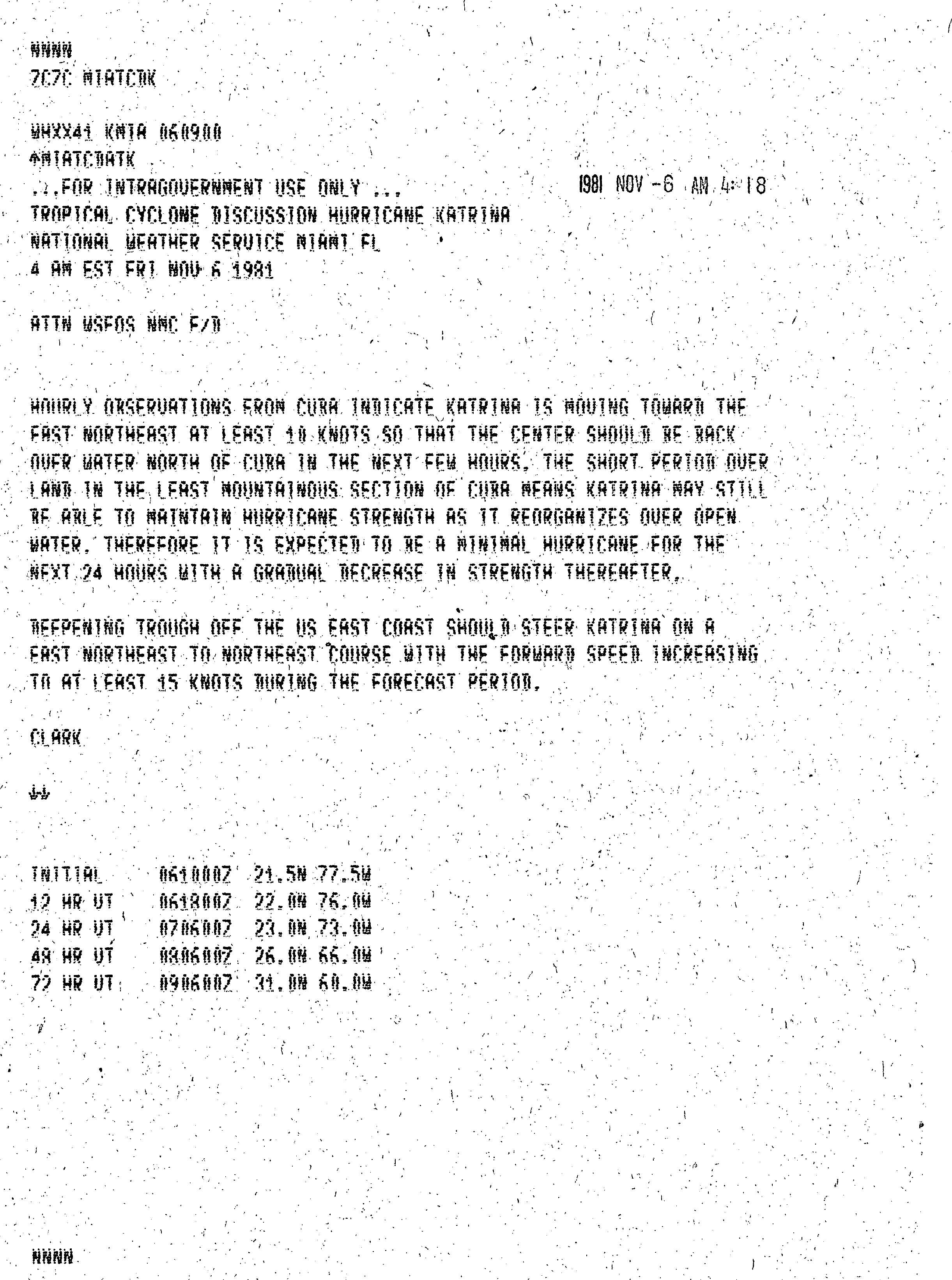
Gilbert B. Clark (November 6, 1981). Tropical Cyclone Discussion Hurricane Katrina. National Hurricane Center (Report). National Oceanic and Atmospheric Administration. Retrieved December 4, 2013.
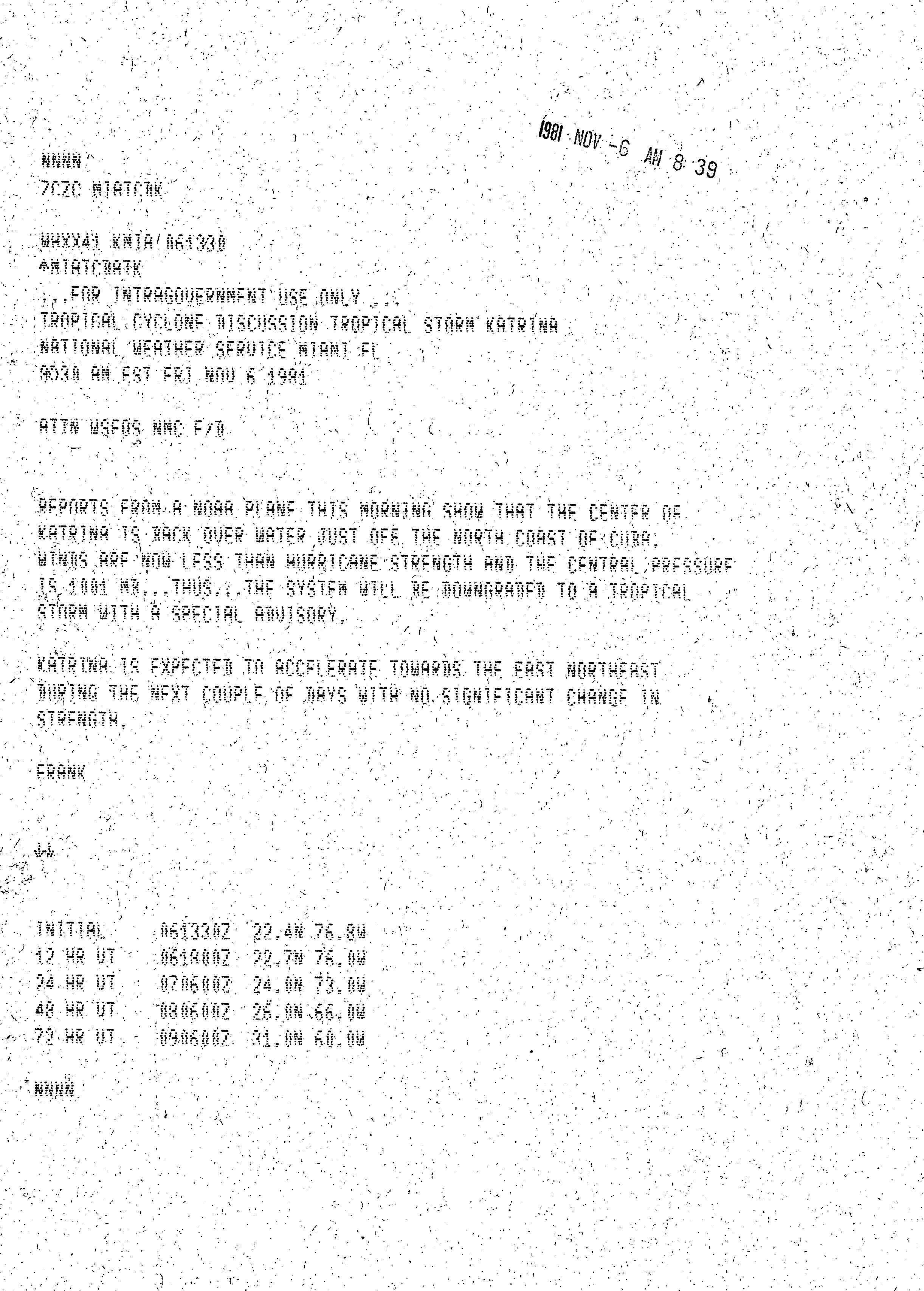
Neil L. Frank (November 6, 1981). Tropical Cyclone Discussion Hurricane Katrina. National Hurricane Center (Report). National Oceanic and Atmospheric Administration. Retrieved December 4, 2013.
Tipton (November 16, 1981). Hurricane Katrina Passes Over Cuba. National Hurricane Center (Report). Washington, D.C.: National Oceanic and Atmospheric Administration. Retrieved December 3, 2013.
Staff Writer (November 10, 1981). "Katrina fizzles out after destructive run". Syracuse Herald-Journal. United Press International. p.B-5. Retrieved April 2, 2024– via NewspaperArchive.
.JPG)