| Marker title |
Image |
Year placed |
Location |
Topics |
|---|
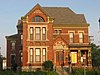
| Lane Place[2] |
 |
1962 |
212 S. Water Street at Wabash Avenue in Crawfordsville
40°2′24″N 86°53′51″W |
Politics, Buildings and Architecture |
| Major General Lew Wallace 1827-1905[3] |
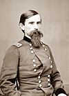 |
1963 |
501 Pike Street at the Wallace Avenue junction in Crawfordsville
40°2′26.6″N 86°53′43″W |
Military, Arts and Culture |
| Chief Cornstalk's Village[4] |
 |
1981 |
Junction of U.S. Route 231 and County Road 1150S, adjacent to Parkersburg Spring near Parkersburg
39°52′23″N 86°54′11″W |
American Indian/Native American, Early Settlement and Exploration |
| Darlington Covered Bridge[5] |
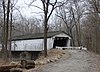 |
1993 |
County Roads 500N and 600E at the southwestern corner of this bridge over Sugar Creek, near Darlington
40°6′27″N 86°47′37″W |
Transportation, Buildings and Architecture |
| Speed Cabin[6] |
|
1995 |
310 N. Grant St. in Crawfordsville
40°2′41.2″N 86°54′15″W |
Underground Railroad; African American; Black History |
| Montgomery County Rotary Jail[7] |
 |
2000 |
Old Jail Museum at 225 N. Washington Street (U.S. Route 231) by the Spring Street junction in Crawfordsville
40°2′38″N 86°54′6″W |
Government Institutions, Buildings and Architecture |
| William Bratton, Lewis and Clark Expedition Member[8] |
|
2002 |
Eastern side of the junction of U.S. Route 136 and State Road 25 at Old Pioneer Cemetery on the eastern edge of Waynetown
40°5′16″N 87°3′33″W |
Early Settlement and Exploration, Cemetery |
| Crawfordsville's Carnegie Library[9] |
 |
2009 |
Carnegie Museum of Montgomery County, 222 S. Washington Street (U.S. Route 231) in Crawfordsville
40°02′23″N 86°54′4″W |
Education & Libraries, Buildings & Architecture, Women |
| Henry S. Lane[10] |
 |
2012 |
212 S. Water St. Crawfordsville
40°02′22″N 86°53′53″W |
Politics |
| Dr Mary Holloway Wilhite, 1831-1892[11] |
 |
2020 |
Northwest corner of S. Grant Ave. and W. Wabash Ave., Crawfordsville
40°02′22.7″N 86°54′15.7″W |
Science, Medicine, & Invention; Women |


.jpg)