| Map |
Island group
(other names) |
Location |
Coordinates |
Area |
Highest peak
Altitude |
Notes |
|---|
 |
Antipodes Islands[4]
(Moutere Mahue) |
New Zealand Subantarctic Islands, 860 kilometres (530 mi) east-southeast of Stewart Island / Rakiura |
49°41′S 178°48′E |
21 square kilometres (8.1 sq mi) |
Mount Galloway
366 m (1,201 ft) |
Part of the New Zealand Subantarctic Islands World Heritage Site |
 |
Auckland Islands[5]
(Motu Maha, Maungahuka) |
New Zealand Subantarctic Islands, 360 kilometres (220 mi) of Stewart Island / Rakiura |
50°42′S 166°05′E |
625.64 square kilometres (241.56 sq mi) |
Mount Dick
705 m (2,313 ft) |
Part of the New Zealand Subantarctic Islands World Heritage Site |
 |
Bounty Islands[6]
(Moutere Hauriri) |
New Zealand Subantarctic Islands, roughly 670 km (416 mi) east-south-east of New Zealand's South Island and 530 km (329 mi) south-west of the Chatham Islands |
47°46′S 179°02′E |
1.35 square kilometres (0.52 sq mi) |
Unnamed point on Funnel Island
73 m (240 ft) |
Part of the New Zealand Subantarctic Islands World Heritage Site |
 |
Campbell Islands[7]
(Motu Ihupuku) |
New Zealand Subantarctic Islands, 360 kilometres (220 mi) of Stewart Island / Rakiura |
52°32′S 169°09′E |
113.31 square kilometres (43.75 sq mi) |
Mount Honey
558 m (1,831 ft) |
Part of the New Zealand Subantarctic Islands World Heritage Site |
 |
Chatham Islands[8]
(Rēkohu, Wharekauri) |
South Pacific Ocean, roughly 800 kilometres (500 mi) east of New Zealand's South Island |
43°54′S 176°32′W |
966 square kilometres (373 sq mi) |
Unnamed point on Chatham Island
299 m (981 ft) |
Largest outlying island group, and the only one with a permanent population (730 as of June 2023[9]). |
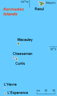 |
Kermadec Islands[10]
(Rangitāhua) |
South Pacific Ocean, roughly 800–1,000 kilometres (500–620 mi) north of New Zealand's North Island |
29°16′S 177°55′W |
33.6 square kilometres (13.0 sq mi) |
Moumoukai Peak
516 m (1,693 ft) |
Northernmost outlying island group, consisting of a range of volcanic islands which are part of the wider Tonga-Kermadec Ridge. Despite having no permanent population, a meteorological station on Raoul Island is permanently staffed. |
 |
Manawatāwhi / Three Kings Islands[11]
(Ngā Motu Karaka) |
Convergence of the Tasman Sea and the South Pacific Ocean, roughly 55 kilometres (34 mi) northwest of Cape Reinga / Te Rerenga Wairua |
34°09′S 172°08′E |
6.85 square kilometres (2.64 sq mi) |
Unnamed point on Manawatāwhi / Great Island
295 m (968 ft) |
Northernmost outlying island group, consisting of a range of volcanic islands which are part of the wider Tonga-Kermadec Ridge. |
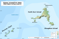 |
Snares Islands / Tini Heke[12]
(Te Taniwha) |
New Zealand Subantarctic Islands, 200 kilometres (120 mi) south of New Zealand's South Island |
48°01′S 166°32′E |
3.5 square kilometres (1.4 sq mi) |
Unnamed point on North East Island
130 m (430 ft) |
Part of the New Zealand Subantarctic Islands World Heritage Site. Given a dual name with the Ngāi Tahu Claims Settlement Act 1998. |
 |
Solander Islands / Hautere[13] |
West of the Foveaux Strait, roughly 50 kilometres (31 mi) south of Fiordland on New Zealand's South Island |
46°34′S 166°53′E |
1.2 square kilometres (0.46 sq mi) |
Unnamed point on Solander Island / Hautere
330 m (1,080 ft) |
Only outlying island group to fall within the authority of a regional council, in this case Environment Southland. Given a dual name with the Ngāi Tahu Claims Settlement Act 1998. |
|


