Tropical Storm Arthur was the first tropical cyclone and named storm of the annual Atlantic hurricane season that caused minimal flooding in the Carolinas in mid-June1996. Arthur originated from an area of increased convection east of the Bahamas on June16. Gradually, the system increased in organization, and was designated as a tropical depression on June17. The depression tracked north-northwest and became Tropical Storm Arthur while just offshore the Southeastern United States on June19. Later that day, Arthur peaked with maximum sustained winds of 45mph (75km/h), but weakened slightly before making landfall in North Carolina early the following day. After striking North Carolina, Arthur tracked out to sea and weakened further to a tropical depression. By June21, Arthur transitioned into an extratropical cyclone. Overall, impact from Arthur was minimal, limited to light rainfall and moderate surf in North and South Carolina, as well as a tornado in Florida. Total damage amounted to $1million (1996USD), but no fatalities were reported.[1]
Quick Facts Meteorological history, Formed ...
Tropical Storm Arthur
Tropical Storm Arthur at peak intensity just off the coast of North Carolina on June 19
On June16, satellite imagery revealed an area of increased convection east of the Bahamas, which was believed to have been associated with a tropical wave.[2] On June17, the convection increased in organization at the lower levels of the atmosphere. By 1800UTC, the system had organized sufficiently to be designated as a tropical depression, making it the first of the season. Initially, the depression tracked north-northwest under the steering currents of the low-level flow around the western periphery of the Atlantic subtropical ridge. Strong wind shear due to fast upper-level winds associated with a cold-core low over the eastern Gulf of Mexico hindered further intensification for a time, but on June18, an area of deep convection developed north of the center of circulation. Based on analysis of reconnaissance data, the tropical depression was upgraded to Tropical Storm Arthur at 1900UTC on June19.[3]
Further strengthening occurred, as the storm attained peak winds of 45mph (75km/h).[2] With time, Arthur gradually turned northeast and made landfall near Cape Lookout, North Carolina early on June20. The center moved over the Pamlico Sound and the Cape Hatteras National Seashore and exited into the Atlantic. Although the storm contained minimal deep convection, satellite imagery indicated that Arthur had a well-defined low-level center. The tropical storm weakened to a tropical depression about 100mi (160km) northeast of Cape Hatteras, and accelerated towards the northeast when westerly steering currents increased. Deep convection increased once again on June21, although the lack of symmetry indicated that the remnants of Arthur were losing tropical characteristics. Forward speed increased to 40mph (64km/h) and the storm subsequently lost all tropical characteristics at 1200UTC on June21, while centered about 350mi (560km) north-northeast of Bermuda. The extratropical remnants tracked northeastward for 36hours, and were last identified about midway between Newfoundland and the Azores, where it was absorbed by a much larger extratropical cyclone over the North Atlantic.[3]
Preparations and impact
Radar imagery of Tropical Storm Arthur impacting North Carolina
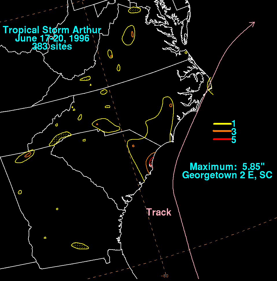
One tornado touched down in Florida, causing no known fatalities or injuries.[4] As the center of Arthur passed 75mi (121km) east of Cape Romain, South Carolina, minor increases in surf were reported. In North Carolina, swells ranged as high as 7ft (2.1m).[1] Rainfall peaked at 5.85 inches (149mm) in Georgetown, South Carolina,[5] though because it fell gradually, no significant flooding was reported,[6] other than minor ponding of water on roads.[7] In addition, Arthur also brought precipitation to Georgia and Virginia, though the amounts of rainfall recorded rarely exceeded 3 inches (76mm). Sustained winds of 46mph (74km/h) were reported, and offshore, the Atlantic Huron reported a sustained wind of 48mph (77km/h) at 1500UTC on June19, while located 35mi (56km) southeast of Arthur's center. In addition, a C-Man station located about 34.5mi (55.5km) southeast of Cape Fear, North Carolina reported sustained winds of 39mph (64km/h) and gusts up to 45mph (75km/h).[3] Overall, damage caused by Arthur was minimal, totaling only $1million (1996USD).[1]