Tropical Storm Candy produced minor impact in the state of Texas during the 1968 Atlantic hurricane season. The third tropical cyclone of the annual season, it developed from a tropical disturbance in the southwestern Gulf of Mexico on June22. Gradual strengthening occurred, with the depression becoming Tropical Storm Candy on the following day. The storm reached its peak intensity of 70mph (110km/h) later that day and made landfall Port Aransas, Texas on June23. Candy weakened into a tropical depression only hours after moving inland. However, the system remained a designated cyclone until June26, at which time it completed extratropical transition over the state of Michigan.
Due to rainfall from a trough for several days, combined 11 inches (280mm) in some areas from Candy itself, flooding occurred in eastern Texas; there was minor damage to crops, roads, and bridges. Agricultural losses alone were slightly less than $2million (1968USD). Storm surge along the coast of Texas caused "cuts" on Padre Island. The storm spawned 24tornadoes, though only one caused significant impact. Candy and its remnants dropped rainfall in 24other states, reaching as far north as New Hampshire. Overall, the system caused $2.7million in damage and no fatalities.
Meteorological history
Map plotting the storm's track and intensity, according to the Saffir–Simpson scale
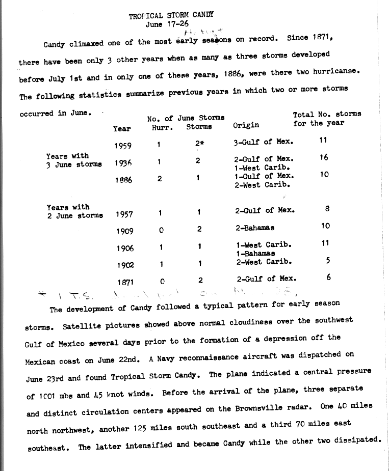
Between mid- to late June, satellite imagery indicated above normal amounts of shower and thunderstorm activity over the southwestern Gulf of Mexico. By June22, the system developed into a tropical depression just off the coast of Mexico in the Bay of Campeche.[1] The depression, which initially had an elongated structure,[2] moved north to north-northwestward at roughly 23mph (37km/h).[3] On June22, three separate and distinct circulation centers were noted in weather radar images from Brownsville, Texas.[1] Later that afternoon, a United States Navyreconnaissance aircraft investigated the depression and recorded sustained winds of 50mph (80km/h) and a minimum barometric pressure of 1,001mbar (29.6inHg). Therefore, the system was upgraded to Tropical Storm Candy at 1800UTC on that same day.[3]
Late on June23, Candy made landfall near Port Aransas, Texas. Despite moving ashore, Candy attained its peak intensity at 0000UTC on June24, with maximum sustained winds of 70mph (110km/h) and a minimum barometric pressure of 999mbar (29.5inHg).[3] Both were observations from a weather station in Austwell, Texas.[2] The storm quickly weakened inland, falling to tropical depression status early on June24.[3] In advance of a cold front, Candy curved northeastward on June25 and began to accelerate. While moving across the Midwestern United States, the storm began to lose tropical characteristics due to the presence of cold air.[2] At 0000UTC on June26, Candy transitioned into an extratropical cyclone while situated over southern Michigan. The remnants continued eastward for several more hours before dissipating over western New York.[3]
Impact and aftermath
Rainfall totals for the storm
Gale-force winds were reported from Corpus Christi to Galveston, Texas. Sustained winds were above 60mph (97km/h) for more than an hour at Austwell, Texas. The peak wind gust of 71mph (114km/h) was measured at Port Aransas, Texas, where the storm made landfall. Storm surge was highest in San Antonio and Corpus Christi Bays, at 4 feet (1.2m), and was 2 to 3 feet (0.61 to 0.91m) along the rest of the Texas coast. However, damage from the storm surge was confined to the formation of "cuts" along Padre Island and to coastal oil refinery equipment.[4]
Prior to the formation of Candy, a trough had brought eight to ten days of rainfall throughout Texas which helped the heavy rainfall from the storm produced damage to crops, roads, and bridges throughout eastern Texas. The rains from Candy also caused flooding on many middle and upper coastal rivers with significant damage confined to the eastern and western forks of the San Jacinto River. The highest recorded rainfall was 11.28 inches (287mm) at Point Comfort, Texas. Elsewhere in southeast Texas, precipitation amounts were generally 3 to 6 inches (76 to 152mm).[4] Impact from winds was mostly minor, except at the 740 feet (230m) public fishing pier in Port O'Connor, which was severely damaged by 65mph (100km/h) winds. Ten towboats and barges, as well as several other small vessels, received minor impacts at Hopper's Landing on San Antonio Bay.[5]
Outside of Texas, 2 to 4 inches (51 to 102mm) of rain was reported in eastern Oklahoma, northwestern Arkansas, central Missouri, and northern Illinois.[4] Precipitation in Michigan exceeded 6 inches (150mm) in some areas,[6] contributing to the ongoing flooding event in Ann Arbor.[7] Flash flooding was reported in western New York, due to precipitation amounts up to 3.04 inches (77mm) in Buffalo during a 24–hour period. As a result, streams overflowed their banks, inundating many basements, sewers, and underpasses.[8] While tropical, Candy spawned 19tornadoes or funnel-clouds to form between June23 and 25. Ten were reported in Texas, five in Arkansas, three in Louisiana, and one in Missouri. Five additional tornadoes, which were associated with the extratropical remnants of Candy, were reported on June25 in eastern Ohio. Despite the amount of tornadoes, only one caused significant damage. That tornado "nearly demolished" a school in Morning Star, Arkansas.[4] The total property damage from the storm was "conservatively" estimated at $1million, while losses to agriculture in eastern Texas approached $2million. No deaths were reported in relation to the storm.[4]
This article uses material from the Wikipedia article Tropical_Storm_Candy, and is written by contributors.
Text is available under a CC BY-SA 4.0 International License; additional terms may apply. Images, videos and audio are available under their respective licenses.