Volcanic eruption lights up Iceland after weeks of earthquake warnings − a geologist explains what's happening
Iceland is known as ‘the land of fire and ice’ for a reason.
Dec. 19, 2023 • 8 min • Source
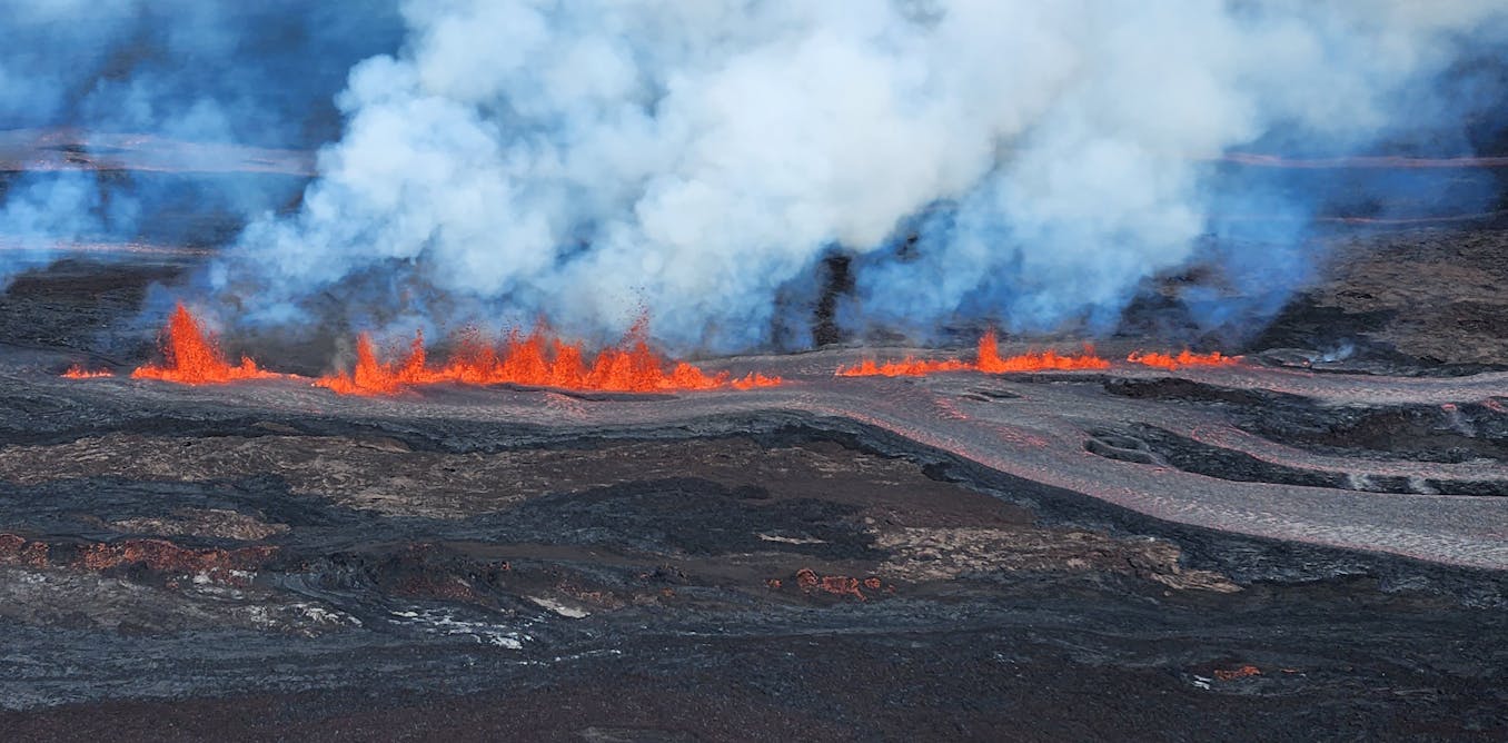
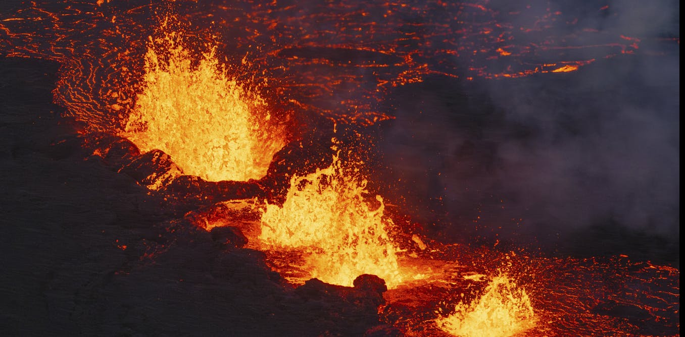
Lava erupted through a fissure in Iceland’s Reykjanes Peninsula on Dec. 18, 2023, shooting almost 100 feet (30 meters) in the air in its early hours.
Icelanders had been anticipating an eruption in the area for weeks, ever since a swarm of thousands of small earthquakes began on Oct. 23 northeast of the fishing town of Grindavík, signaling volcanic activity below.
In the days that followed those first rumblings, a series of small rifts opened under the town, breaking streets, rupturing utility lines and tilting houses. GPS stations detected the ground sinking and rising over a large area.
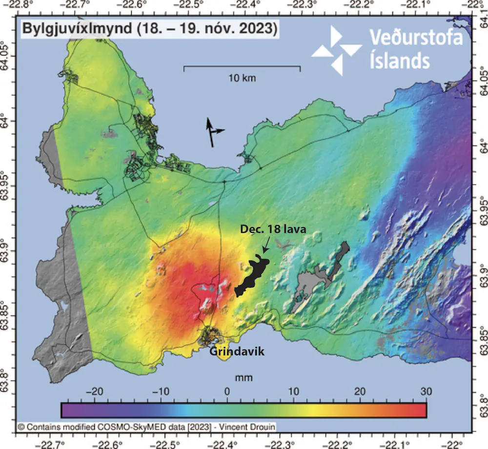
Geologists from the Icelandic Met Office interpreted the events as evidence that a basalt dike – pressurized magma that forces its way into a fracture – had intruded under Grindavík. The activity there had tapered off by early December, but 2.5 miles (4 kilometers) north of town, the ground under the Svartsengi geothermal power plant was moving.
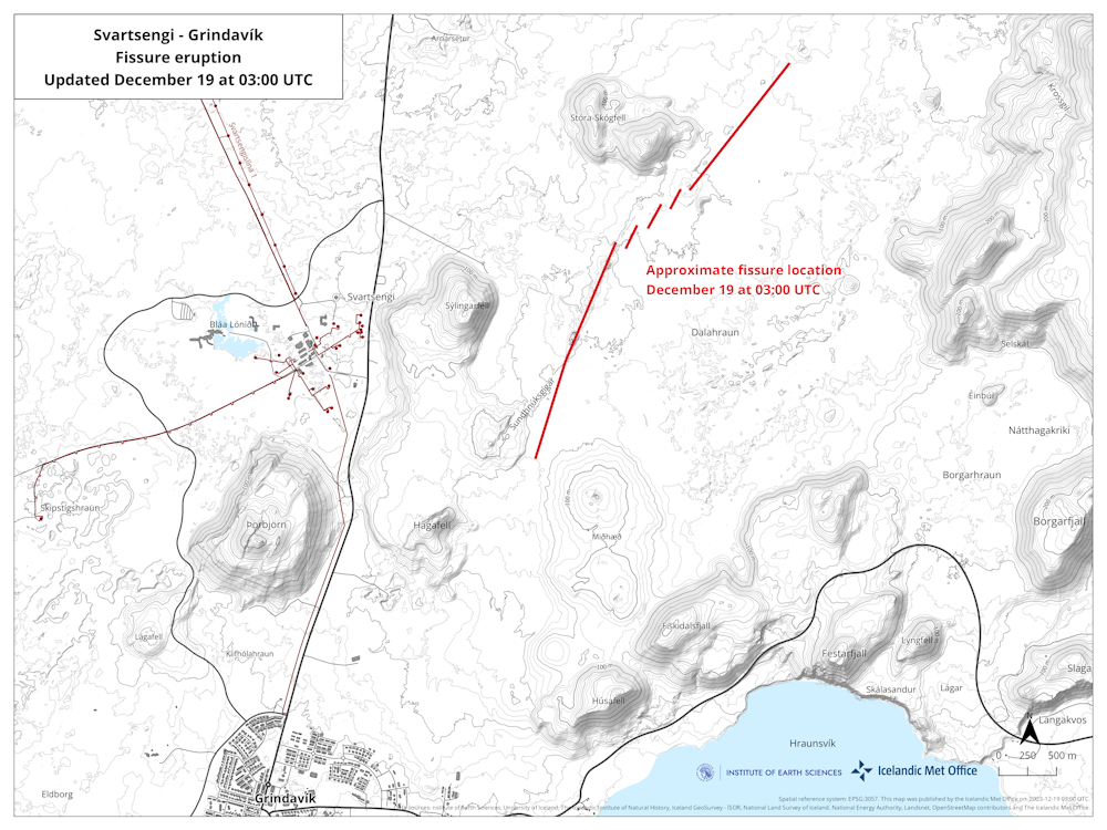
The ground had dropped 10 inches (25 centimeters) as the basalt dike filled, but then it began to rise in a broad dome, indicating that magma was reinflating and repressurizing the magma chamber. The result was the nearby eruption on Dec. 18.
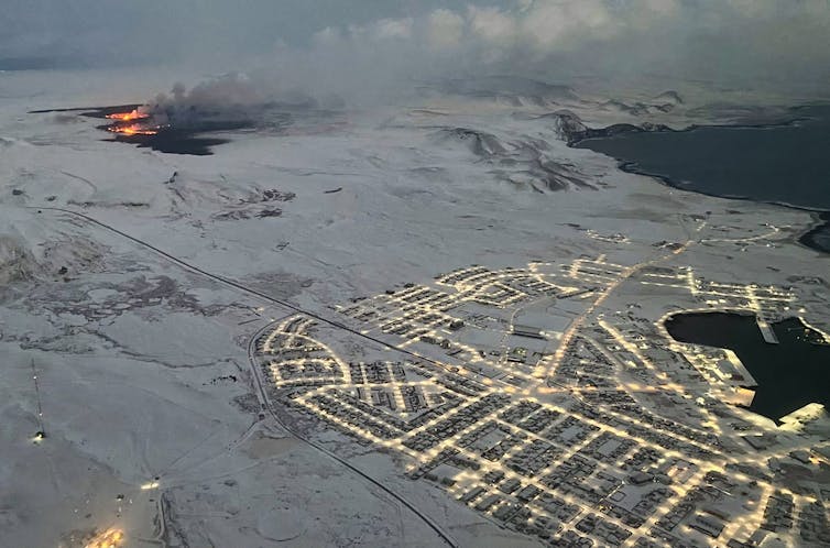
If the fissure continues to propagate to the south, or if a large volume of lava erupts, the evacuated town of Grindavík, with a population of around 3,500, may be in danger. The lava could also spill to the northwest toward the power plant, although the utility built rock walls to try to divert lava flows.
Iceland is known as “the land of fire and ice” for a reason. Its residents have learned over centuries to live with its overactive geology.
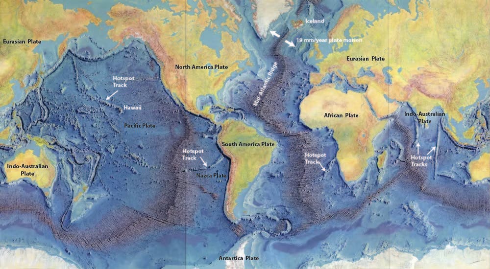
The reason for volcanism has two parts: One has to do with what geologists unimaginatively call a hot spot, and the other involves giant tectonic plates that are pulling apart right beneath the island. As a geologist, I study both.
Life on the edge of two tectonic plates
When plate tectonic theory was emerging in the 1960s, geologists realized that many volcanoes are located in zones where tectonic plates meet. Tectonic plates are gigantic chunks of Earth’s rigid outer layer that carry both continents and oceans and are constantly in motion. They cover the planet like large pieces of a spherical jigsaw puzzle.
Many of these volcanoes are in subduction zones, like the Pacific’s Ring of Fire, where thinner oceanic plates slowly sink into Earth’s mantle. These are the postcard stratovolcanoes like Mount Fuji, in Japan, or Mount Rainier, outside of Seattle. Because of their high gas content, they tend to erupt catastrophically, shooting ash high into the atmosphere with the energy of nuclear bombs, as Mount St. Helens did in 1980.
A second, typically quieter kind of volcano forms where plates pull apart.
The volcanic activity near Grindavík is directly related to this kind of plate tectonic motion. The mid-Atlantic ridge between the Eurasian and North American plates cuts right through that part of the island.
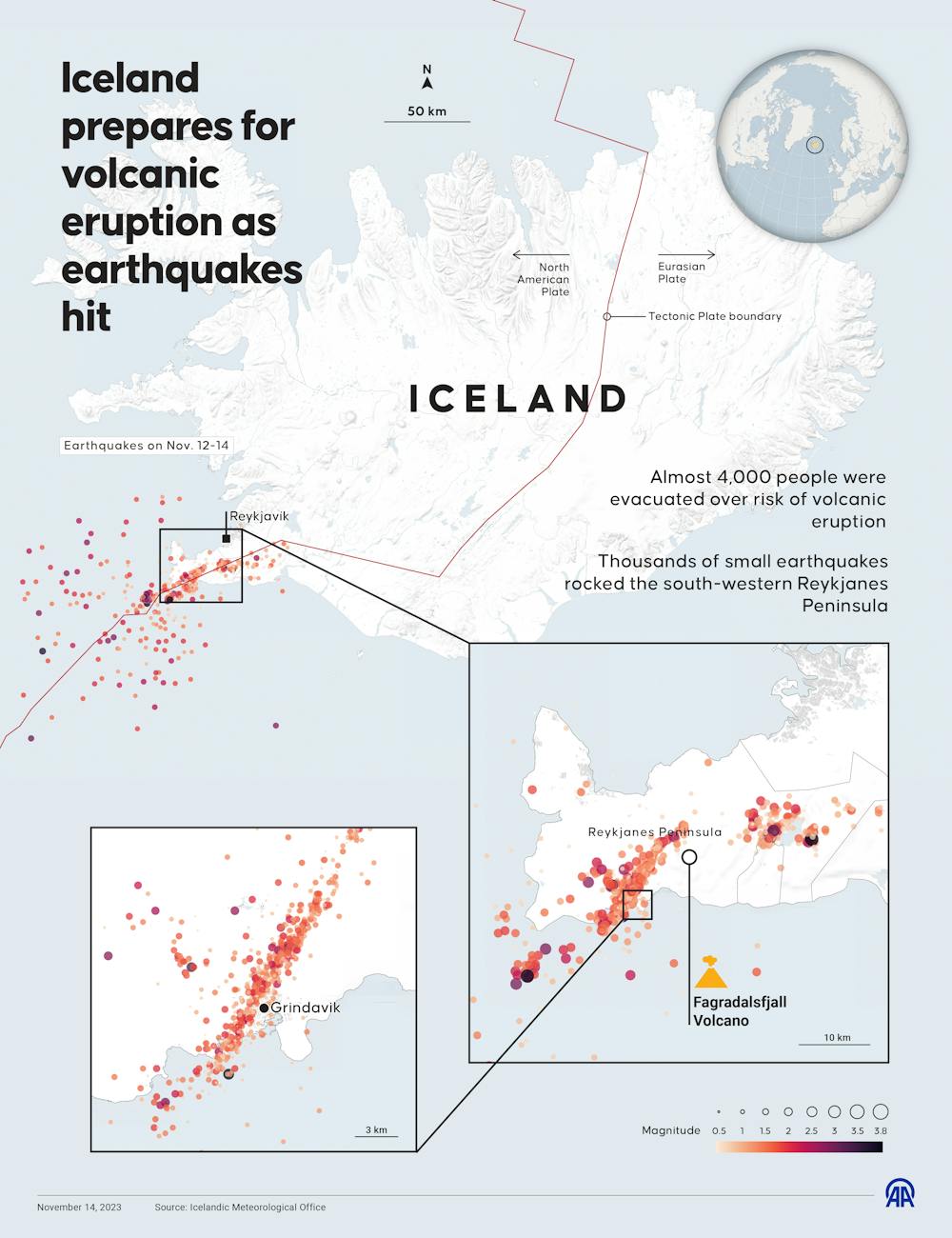
In fact, at Thingvellir National Park you can literally walk between the two tectonic plates. You can see the topographic scars of the rift in the long, linear valleys that extend to the northeast from Grindavík. They align with the swarms of earthquakes, the ground deformation, and the fissure eruption of 2023.
Where plates pull away from each other, the underlying mantle rises toward the surface to fill the gap, carrying its heat with it and moving into an area of lower pressure. Those two processes cause melting at depth and volcanic activity at the surface.
This is the same process that creates new oceanic crust underwater at mid-ocean ridges. After the magma solidifies as basalt rock, it will look like vertical walls intruded into the surrounding area.
Sitting on a hot spot
In Iceland, the large volcanoes in the interior also appear to be over a mantle plume, similar to Hawaii.
This kind of volcano typically erupts basalt lava, which melts at very high temperature and tends to flow easily. Eruptions are generally not explosive because the runny lava allows gases to escape.
Exactly what causes hot material to rise at hot spots is still debated, but the most commonly accepted idea is that they are caused by plumes of super-heated rock that originate at the transition between Earth’s metallic core and rocky mantle. Hot spots are a mechanism for the Earth to give off some of its internal heat.
Typically, fissure eruptions are not explosive. However, when lava that is 1,800 degrees Fahrenheit (about 1,000 degrees Celsius) hits water, the flash to steam can cause explosions that can scatter ash over a larger area.
A silver lining of Iceland’s volcanoes
Living in an active volcanic area has some advantages, particularly for energy.
Iceland derives 30% of its electricity from geothermal sources that use underground heat to drive turbines and produce power. It’s almost like a controlled version of a lava flow hitting the sea, and it helps make Iceland one of the cleanest economies on earth.
The Svartsengi hydrothermal plant uses the underground heat from the same magma chamber that is now erupting to provide hot water for several thousand homes, plus 75 megawatts of electricity.
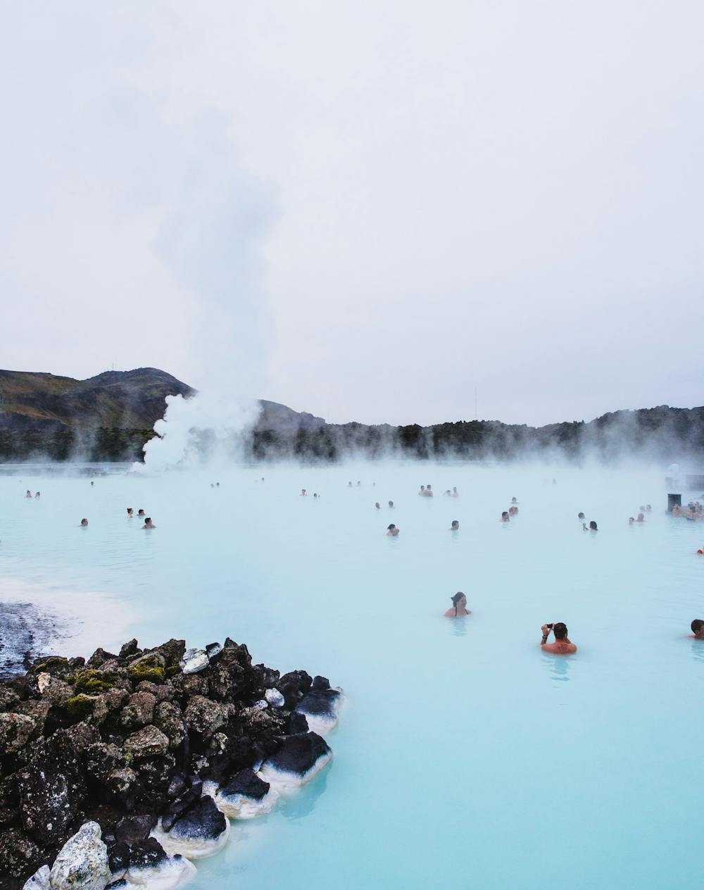
That power plant is also part of the reason the Blue Lagoon is so popular. When the power plant was built in 1976, the plan was to discharge its still hot wastewater into an adjacent low area, expecting that it would seep into the ground. However, the geothermal water was loaded with dissolved silica, which became solid minerals when the water cooled, creating an impermeable layer. A small lake began to form.
Because of its high silica content, the water in this lake is a spectacular blue color that inspired the creation of the geothermal spa. The Blue Lagoon is one of the top tourist attractions in the country.
Now the Blue Lagoon is at risk: Sometimes the volcano gives, sometimes it takes away.
This is an updated version of an article published Nov. 15, 2023.
Jaime Toro works for West Virginia University. In the past, he has received funding from NSF, USGS and DOE.
Share this article:
Related Articles:

Volcanic Iceland is rumbling again as magma rises − a geologist explains eruptions in the land of fire and ice
Nov. 15, 2023 • conversation