
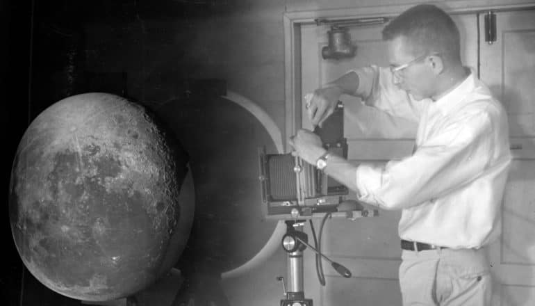
William Hartmann projecting photographic plates of the moon onto a white hemisphere to create the Rectified Lunar Atlas. (Credit: U. Arizona Lunar and Planetary Laboratory)
How moon maps made the lunar landing possible
Before humans could walk on the moon's face, researchers had to image and map its surface. This video explains the clever way they got it done.
Before NASA sent Americans to the moon, researchers had to image and map the lunar surface.
The maps allowed them to understand the moon’s geology and let NASA choose landing sites for future robotic and Apollo missions.
Gerard Kuiper, the father of modern-day planetary sciences, led the team that published two atlases. The Rectified Lunar Atlas (1963) gave people a first look at what features on the moon’s edges looked like without distortion, as explained in this video.
The Consolidated Lunar Atlas (1967) was comprised of the highest resolution images taken from the ground, mostly from the Santa Catalina Mountains in Southern Arizona. These atlases not only paved the way to the moon, but also birthed the field of planetary science.
Here, Timothy Swindle, director of the Lunar & Planetary Lab at the University of Arizona, explains an innovative technique researchers used:
You can read more about the importance of the moon maps to lunar missions here. Today, researchers are busy mapping other parts of our solar system.
Source: University of Arizona
The post How moon maps made the lunar landing possible appeared first on Futurity.
Share this article:
This article uses material from the Futurity article, and is licenced under a CC BY-SA 4.0 International License. Images, videos and audio are available under their respective licenses.
Related Articles:
How the moon landing still shapes our lives
July 16, 2019 • futurity
Lunar samples from Apollo 11 still influence research
July 20, 2019 • futurityLinks/images:
- https://www.lpl.arizona.edu/sic/collection/rla
- https://www.lpi.usra.edu/resources/cla/
- https://uanews.arizona.edu/story/how-university-arizona-guided-men-moon
- https://uanews.arizona.edu/story/mapping-moon-and-worlds-beyond
- https://www.futurity.org/moon-maps-lunar-landing-2109642/
- https://www.futurity.org