1827_Finley_Map_of_Africa_-_Geographicus_-_Africa-finley-1827,_crop.jpg
Size of this preview:
706 × 599 pixels
.
Other resolutions:
283 × 240 pixels
|
565 × 480 pixels
|
905 × 768 pixels
|
1,179 × 1,001 pixels
.
|
Anthony Finley
: Africa.
(
|
||||||||||||||
|---|---|---|---|---|---|---|---|---|---|---|---|---|---|---|
| Artist |
|
|||||||||||||
| Title |
Africa.
|
|||||||||||||
| Description |
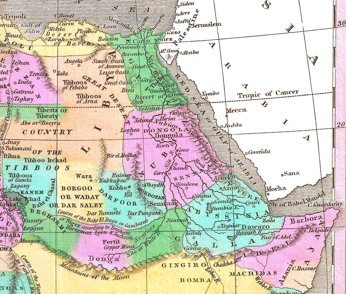
Afrikaans:
'n Pragtige voorbeeld van Anthony Finley se invloedryke kaart van Afrika, wat deur Young en Delleker gegraveer is vir die 1827-uitgawe van Finley se
General Atlas
. Die titel en skaal is links onder. Hierdie uitsonderlike kaart het die sterk eskalasie in verkenning van Afrika tydens die mid-19de eeu voorafgegaan, en die binneland van Afrika bly hier grotendeels onbekend. Die Ptolemaïese
Berge van die Maan
word aangedui as 'n bergreeks wat wes na oos oor die sentrale deel van die kontinent strek, met die suggestie dat verskeie takke van die Nyl hier ontspring. Verskeie spekulatiewe lope van die Nigerrivier word aangedui, met een wat by die Nyl aansluit, 'n ander wat suid van die
Berge van die Maan
die Kongo binnevloei, en nog 'n ander wat korrek getoon word met 'n kromming na 'n monding in die Golf van Bonny / Biafra. Regdeur word etlike etniese groepe aangedui, waaronder die Pomba, Jaga, Timboektoe, Toeareg, Tibboe, Bambara en ander. Ook word 'n land van kannibale in Mosambiek onderskei.
English:
A beautiful example of Finley's important 1827 map of Africa. This uncommon map predates the explosion of African exploration that occurred in the mid 19th century. Much of the interior remains unknown. The Ptolemaic Mountains of the Moon are drawn stretching across the central part of the continent with the suggestions that they are the source of several branches of the Nile. Several speculative courses are drawn for the Niger River, one of which joins it to the Nile, another of which flows south of the Mountains of the Moon into the Congo, and yet another of which, correctly, bends southwards to empty into the Bight of Biafra. It identifies numerous African tribes throughout, including the Pomba, Jaga, Timbuctoo, Tuareg, Tibboos, Bambara, and others. It also identifies a land of cannibals in Mozambique. Title and scale in lower left quadrant. Engraved by Young and Delleker for the 1827 edition of Anthony Finley's General Atlas.
|
|||||||||||||
| Date | 1827 (undated) | |||||||||||||
| Dimensions | height: 11.5 in (29.2 cm); width: 9 in (22.8 cm) | |||||||||||||
| Accession number |
Geographicus link:
Africa-finley-1827
|
|||||||||||||
| Source/Photographer |
Finley, Anthony, A New General Altas, Comprising a Complete Set of Maps, representing the Grand Divisions of the Globe, Together with the several Empires, Kingdoms and States in the World; Compiled from the Best Authorities, and corrected by the Most Recent Discoveries , Philadelphia, 1827.
|
|||||||||||||
|
Permission
( Reusing this file ) |
|
|||||||||||||
| Other versions |

|
|||||||||||||