1851_map_New_Bedford_Massachusetts_by_Walling_BPL_10676.png
Size of this preview:
632 × 600 pixels
.
Other resolutions:
253 × 240 pixels
|
506 × 480 pixels
|
709 × 673 pixels
.
| Description |
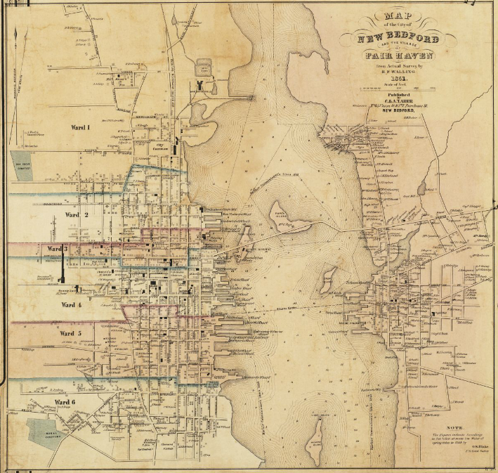
Map of the City of New Bedford and the Village of Fair Haven, from actual survey by H.F. Walling. Author: Walling, Henry Francis Publisher: C. & A. Taber (Firm) Date: 1851 Location: Bristol County (Mass.), New Bedford (Mass.) |
| Date | |
| Source | Boston Public Library / http://maps.bpl.org/id/10676 |
| Author | Walling |
|
|
This media file is in the
public domain
in the
United States
. This applies to U.S. works where the copyright has expired, often because its first
publication
occurred prior to January 1, 1929, and if not then due to lack of notice or renewal. See
this page
for further explanation.
|

|

|
This image might not be in the public domain outside of the United States; this especially applies in the countries and areas that do not apply the
rule of the shorter term
for US works, such as Canada, Mainland China (not Hong Kong or Macao), Germany, Mexico, and Switzerland. The creator and year of publication are essential information and must be provided. See
Wikipedia:Public domain
and
Wikipedia:Copyrights
for more details.
|