1956_Official_Texas_Highway_Map_small.png
Size of this preview:
772 × 600 pixels
.
Other resolutions:
309 × 240 pixels
|
618 × 480 pixels
|
989 × 768 pixels
|
1,280 × 994 pixels
|
2,560 × 1,988 pixels
|
4,507 × 3,500 pixels
.
Summary
| Description |
English:
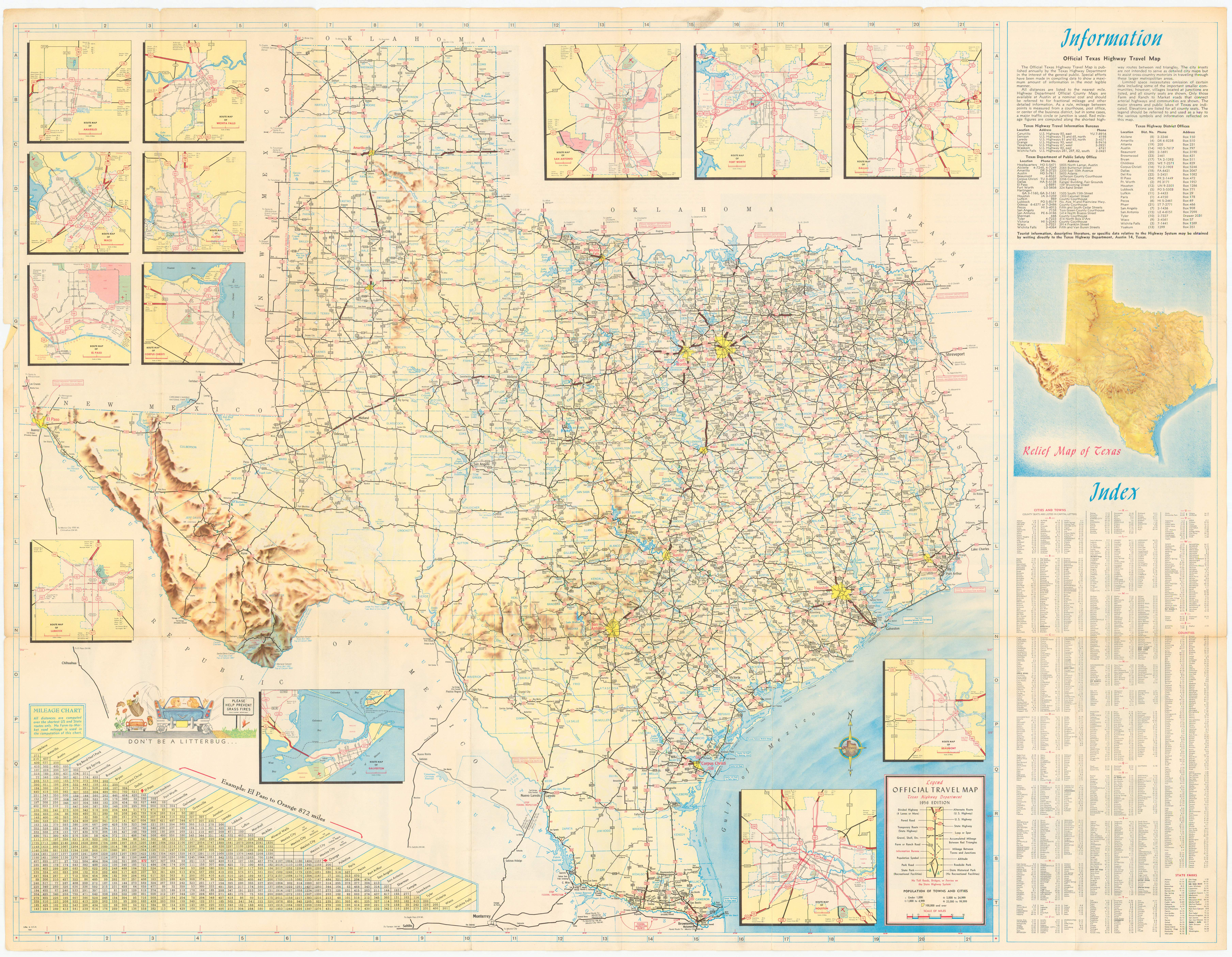
The 1956 edition of the Texas Highway Department published
Official Travel Map
. The
Interstate Highway System
is not present on the map as it had not been created yet.
Route 66
travels through the panhandle region. In addition to Texas, inset maps of
Amarillo
,
Wichita Falls
,
Waco
,
Austin
,
El Paso
,
Corpus Christi
,
Lubbock
,
Galveston
,
Houston
,
Beaumont
,
Dallas
,
Fort Worth
, and
San Antonio
.
|
| Date | |
| Source | Texas 1956 Official State Map on Flickr |
| Author | Justin Cozart |
|
Permission
( Reusing this file ) |
The image was created in 1956, as stated in the source image. The above image is in the public domain for the following reason:
|
| Other versions |
File:1956 Official Texas Travel Map.png
, a larger PNG version
File:1956 Official Texas Highway Map JPEG.jpg , a larger jpg version |
Licensing
|
|
This work is in the
public domain
in the United States because it was
published
in the United States between 1929 and 1977, inclusive,
without a
copyright notice
. For further explanation, see
Commons:Hirtle chart
as well as a
detailed definition
of "publication" for public art. Note that it may still be copyrighted in jurisdictions that do not apply the
rule of the shorter term
for US works (depending on the date of the author's death), such as Canada (50
p.m.a.
), Mainland China (50 p.m.a., not Hong Kong or Macao), Germany (70 p.m.a.), Mexico (100 p.m.a.), Switzerland (70 p.m.a.), and other countries with individual treaties.
|

|

|
This image has been assessed under the valued image criteria and is considered the most valued image on Commons within the scope: Road Maps of Texas , 1956 . You can see its nomination here . |