2017_UK_general_election_constituency_map.svg

Size of this PNG preview of this SVG file:
460 × 600 pixels
.
Other resolutions:
184 × 240 pixels
|
368 × 480 pixels
|
589 × 768 pixels
|
786 × 1,024 pixels
|
1,571 × 2,048 pixels
|
1,477 × 1,925 pixels
.
Legend
Alliance Party
(Northern Ireland)
Undeclared/Delayed
Regional boundaries
Summary
| Description |
English:
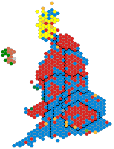
An alternative map showing the results of the
2017 UK General Election
showing constituencies as equal area hexagons and approximate geographic location.
|
| Date | |
| Source | Own work based on: 2015 UK general election constituency map.svg by Ch1902 (previous version) |
| Author | Ch1902 |
| SVG development |
Licensing
|
|
I, the copyright holder of this work, release this work into the
public domain
. This applies worldwide.
In some countries this may not be legally possible; if so: I grant anyone the right to use this work for any purpose , without any conditions, unless such conditions are required by law. |