A_False-Color_Topography_of_Vesta's_South_Pole.jpg

Size of this preview:
600 × 600 pixels
.
Other resolutions:
240 × 240 pixels
|
480 × 480 pixels
|
768 × 768 pixels
|
1,134 × 1,134 pixels
.
Summary
| Description |
Русский:
Топография Южного полюса Весты (4) в искусственных цветах, по центру картер Реясильвия
English:
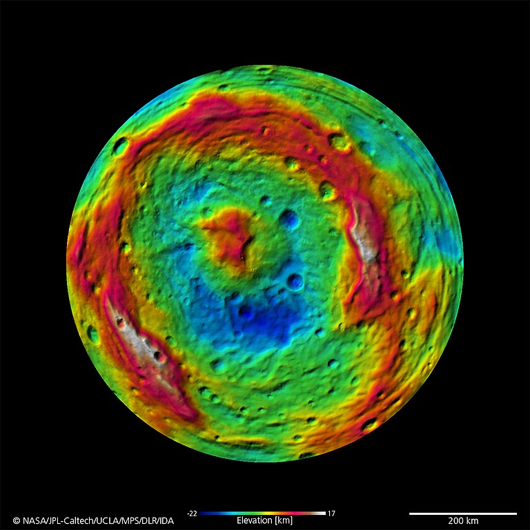
A False-Color Topography of Vesta's South Pole
September 16, 2011 - PASADENA, Calif. -- This false-color map of the giant asteroid Vesta was created from stereo images obtained by the framing camera aboard NASA’s Dawn spacecraft. The image shows the elevation of surface structures with a horizontal resolution of about 750 meters per pixel. The terrain model of Vesta's southern hemisphere shows a big circular structure with a diameter of about 300 miles (500 kilometers), its rim rising above the interior of the structure for more than 9 miles (15 kilometers.) From low-resolution images of the Hubble Space Telescope it was known that a big depression existed at Vesta’s south pole, suggestive of being a big impact basin. Scientists on the Dawn team are still investigating the processes that formed this structure. |
| Date | |
| Source | http://dawn.jpl.nasa.gov/multimedia/dawn_vesta_image_PIA14711.asp |
| Author | NASA |
Licensing
|
|
This file is in the public domain in the United States because it was solely created by NASA . NASA copyright policy states that "NASA material is not protected by copyright unless noted ". (See Template:PD-USGov , NASA copyright policy page or JPL Image Use Policy .) |
|

|
Warnings:
|