Achaemenid_Empire_500_BC.png

Size of this preview:
800 × 427 pixels
.
Other resolutions:
320 × 171 pixels
|
640 × 341 pixels
|
1,024 × 546 pixels
|
1,280 × 683 pixels
|
3,070 × 1,637 pixels
.
Summary
| Description |
English:
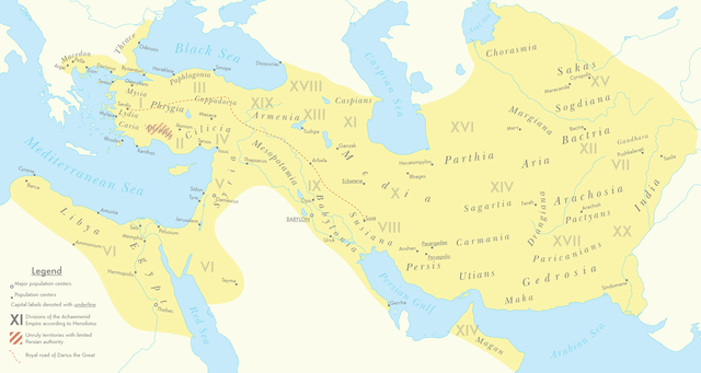
A map of the Achaemenid Empire around 500 BC featuring ancient regions, settlements and Satrapies.
This map assembles information from the Historischer Schul-Atlas zur alten, mittleren und neueren Geschichte by Heinrich Kiepert and Carl Wolff from 1879 as accessed from GEI Digital, the 1923 edition of Historical Atlas by William R. Shepherd as accessed from the Perry-Castañeda Library's online map collection and Livius.org's article on the Satrapies of the Achaemenid Empire according to Herodotus.
|
| Date | |
| Source | Own work |
| Author | Cattette |
Licensing
I, the copyright holder of this work, hereby publish it under the following license:
This file is licensed under the
Creative Commons
Attribution 4.0 International
license.
-
You are free:
- to share – to copy, distribute and transmit the work
- to remix – to adapt the work
-
Under the following conditions:
- attribution – You must give appropriate credit, provide a link to the license, and indicate if changes were made. You may do so in any reasonable manner, but not in any way that suggests the licensor endorses you or your use.