Agri_decumates_Karte.png

Size of this preview:
580 × 600 pixels
.
Other resolutions:
232 × 240 pixels
|
464 × 480 pixels
|
743 × 768 pixels
|
990 × 1,024 pixels
|
1,981 × 2,048 pixels
|
2,950 × 3,050 pixels
.
Summary
| Description |
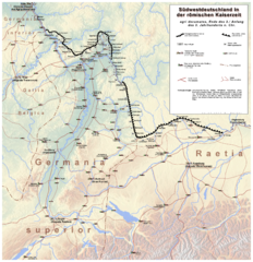
Deutsch:
Südwestdeutschland gegen Ende des 2./ Anfang des 3. Jahrhunderts n. Chr. Karte des Limeshinterlandes (
agri decumates
) mit zivilen Siedlungen.
English:
Southwest Germany towards the end of the 2nd / Beginning of the 3rd Century A.D. Chr. Map of the Limeshinterland (agri decumates) with civilian settlements.
|
| Date | |
| Source | own drawing, sources: www.maps-for-free.com (Relief, license is here ); IMPERIUM ROMANUM, Roms Provinzen an Rhein, Neckar und Donau. (Esslingen 2005), Abb. 31 und 166; Westermann, Großer Atlas zur Weltgeschichte. (Braunschweig 1985), S. 37; diverse Literatur ( Die Römer in Hessen , Die Römer in Bayern , Die Römer in Baden-Württemberg , Die Römer in Rheinland-Pfalz ). |
| Author | Haselburg-müller |
Licensing
I, the copyright holder of this work, hereby publish it under the following license:

|
Permission is granted to copy, distribute and/or modify this document under the terms of the GNU Free Documentation License , Version 1.2 or any later version published by the Free Software Foundation ; with no Invariant Sections, no Front-Cover Texts, and no Back-Cover Texts. A copy of the license is included in the section entitled GNU Free Documentation License . |