Aksai_Chin_Sino-Indian_border_map.svg

Summary
| Description |
English:
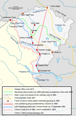
The map shows the Indian and Chinese claims of the border in the Aksai Chin region, the Macartney-MacDonald line, the Foreign Office Line, as well as the progress of Chinese forces as they occupied areas during the Sino-Indian War.
|
||
| Date | |||
| Source |
|
||
| Author | Hogweard | ||
|
Permission
( Reusing this file ) |
|
||
| Other versions | Aksai Chin Sino-Indian border map.png |
The Macartney-MacDonald line is described as follows: "From the Karakoram Pass the crests of the range run nearly east for about half a degree, and then turn south to a little below the 35th parallel.. Rounding... the source of the Karakash, the line of hills to be followed runs north-east to a point east of Kizil Jilga and from there, in a south-easterly direction, follows the Lak Tsung (Lokzhung) Range until that meets a spur.. which has hitherto been shown on our maps as the eastern boundary of Ladakh. [1]
The Macartney-MacDonald line was never accepted by China, although they informally indicated acceptance on certain occasions:
- Woodman, Dorothy (1969) Himalayan Frontiers: A Political Review of British, Chinese, Indian, and Russian Rivalries , Praeger, p. 102 "The proposed boundary seems never to have been considered in the same form again until Alastair Lamb revived it in 1964."
- Lamb, Alastair (1965). " Treaties, Maps and the Western Sector of the Sino-Indian Boundary Dispute ". The Australian Year Book of International Law . "Unfortunately, the Chinese never replied formally to the note, though they indicated informally on a number of occasions their agreement as to its boundary alignment."
In 1959, Chou confirmed the new Chinese claim line to Nehru.
References: ( [2] archive copy at the Wayback Machine [3] [4] [5] [broken links]) [6] Map on last page archive copy at the Wayback Machine [7]
![[2]](http://cpasindia.org/images/sino-india1.jpg)
![[3]](http://www.frontline.in/static/html/fl2018/images/20030912002104801.jpg)
![[4]](http://www.frontline.in/static/html/fl2018/images/20030912002104802.jpg)
![[5]](http://www.frontline.in/static/html/fl2320/images/20061020001608505.jpg)
![[6]](http://www.indiandefencereview.com/wp-content/uploads/2013/06/Aksai-Chin-GOI-Map.jpg)