AlborzCentralColoredNumbered.png

Size of this preview:
800 × 598 pixels
.
Other resolutions:
320 × 239 pixels
|
640 × 478 pixels
|
1,024 × 765 pixels
|
1,345 × 1,005 pixels
.
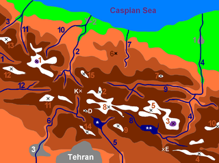
| Map of central Alborz | Peaks: | 1 Alam Kūh |
|---|---|---|

-25
m
to 500m
500m to 1500m
1500m to 2500m
2500 to 3500m
3500m to 4500m
4500m to 5610m
|
2 Azad Kooh | 3 Damāvand |
| 4 Berar | 5 Khaharan | |
| 6 Ghal`eh Gardan | 7 Gorg | |
| 8 [1] | 9 [2] | |
| 10 Mīšīneh Marg | 11 Naz | |
| 12 [3] | 13 Sīālān | |
| 14 [4] | 15 Varavašt | |
| Rivers: | 0 | |
| 1 Alamūt | 2 Chālūs | |
| 3 Do Hezār | 4 Harāz | |
| 5 Jājrūd | 6 Karaj | |
| 7 Kojūr | 8 Lār | |
| 9 Nūr | 10 Sardāb | |
| 11 Seh Hazār | 12 Shāh Rūd | |
| Cities: | 1 Āmol | |
| 2 Chālūs | 3 [5] | |
| Other: | D Dīzīn | |
| E Emāmzādeh Hāšem | K Kandovān Tunnel | |
| * Latīān Dam | ** Lār Dam |
| Description |
English:
Alborz mountain range in northern Iran.
Dansk:
Alborz-bjergkæden i det nordlige Iran.
|
||
| Date | |||
| Source | Map by Michèle Chevalier | ||
| Author | Uploaded to English Wikipedia by Siamax as AlborzCentralColoredNumbered.PNG | ||
|
Permission
( Reusing this file ) |
|
| Annotations | This image is annotated: View the annotations at Commons |