All_Saints_Church_(geograph_7247736).jpg

Size of this preview:
800 × 450 pixels
.
Other resolutions:
320 × 180 pixels
|
640 × 360 pixels
|
1,024 × 577 pixels
|
1,280 × 721 pixels
|
2,560 × 1,441 pixels
|
4,000 × 2,252 pixels
.
Summary
| Description |
English:
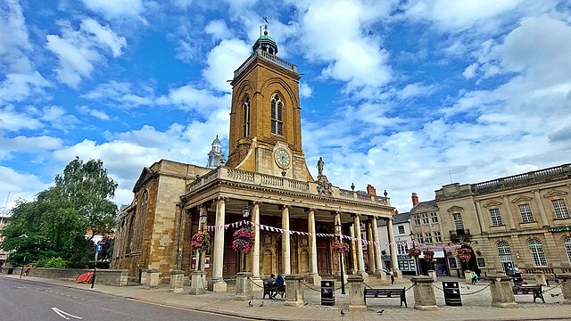
Built to replace All Hallows Church which was destroyed in the Great Fire of Northampton 1675. Charles II gave 1000 tons of timber to rebuild the town, of which 10 per cent was used to build All Saints.
The tower of All Hallows survived and was incorporated into Henry Bell's Christopher Wren-influenced new design, which also includes a dome supported on Ionic columns and a barrel-vaulted nave. The church was consecrated in 1680 and the portico was added in 1701, along with a statue of King Charles. On Oak Apple Day each year the statue is adorned with a wreath of oak leaves. |
| Date | |
| Source | From geograph.org.uk |
| Author | Mark Percy |
|
Permission
( Reusing this file ) |
Creative Commons Attribution Share-alike license 2.0 |
|
Attribution
( required by the license ) |
Mark Percy / All Saints Church / |
| Camera location |
|
View this and other nearby images on: OpenStreetMap |
|
|---|
.jpg¶ms=052.236638_N_-000.897287_E_globe:Earth_type:camera_source:geograph-osgb36(SP754604)_heading:90.00&language=en)
| Object location |
|
View this and other nearby images on: OpenStreetMap |
|
|---|
.jpg¶ms=052.236640_N_-000.897290_E_globe:Earth_class:object_type:object_source:geograph-osgb36(SP754604)_heading:90.00&language=en)
Licensing

|
This image was taken from the
Geograph project
collection. See
this photograph's page
on the Geograph website for the photographer's contact details. The copyright on this image is owned by
Mark Percy
and is licensed for reuse under the
Creative Commons
Attribution-ShareAlike 2.0 license.
|
This file is licensed under the
Creative Commons
Attribution-Share Alike 2.0 Generic
license.
Attribution:
Mark Percy
-
You are free:
- to share – to copy, distribute and transmit the work
- to remix – to adapt the work
-
Under the following conditions:
- attribution – You must give appropriate credit, provide a link to the license, and indicate if changes were made. You may do so in any reasonable manner, but not in any way that suggests the licensor endorses you or your use.
- share alike – If you remix, transform, or build upon the material, you must distribute your contributions under the same or compatible license as the original.