Ankara-Istanbul_HSR_map.png

Size of this preview:
800 × 566 pixels
.
Other resolutions:
320 × 226 pixels
|
640 × 453 pixels
|
1,024 × 724 pixels
|
1,280 × 905 pixels
|
2,560 × 1,810 pixels
|
4,961 × 3,508 pixels
.
Summary
| Description |
English:
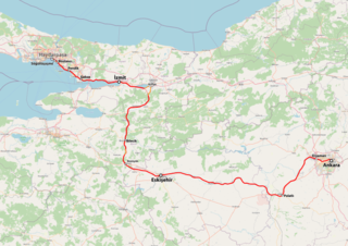
Map of the Ankara-Istanbul high-speed railway. Dotted sections represent the parts of the line that are still under construction. Orange represents the conventional railway YHT use to bypass under construction sections.
|
| Date | |
| Source | Own work |
| Author | Btian P. Dorsam |
Licensing
I, the copyright holder of this work, hereby publish it under the following license:
This file is licensed under the
Creative Commons
Attribution-Share Alike 4.0 International
license.
-
You are free:
- to share – to copy, distribute and transmit the work
- to remix – to adapt the work
-
Under the following conditions:
- attribution – You must give appropriate credit, provide a link to the license, and indicate if changes were made. You may do so in any reasonable manner, but not in any way that suggests the licensor endorses you or your use.
- share alike – If you remix, transform, or build upon the material, you must distribute your contributions under the same or compatible license as the original.