Antarctica_(5),_Adelaide_Island,_Webb_Island.JPG
Size of this preview:
800 × 531 pixels
.
Other resolutions:
320 × 213 pixels
|
640 × 425 pixels
|
1,024 × 680 pixels
|
1,280 × 850 pixels
|
1,716 × 1,140 pixels
.
Summary
| Description |
বাংলা:
এই ছবিটি অ্যান্টার্কটিক উপদ্বীপের দক্ষিণ-পশ্চিম অঞ্চলের। এটি
লুব্যফ সাগরখাঁড়ির
উপর থেকে দ.-প. দিকে নেয়া একটি আন্তরীক্ষ দৃশ্য। ছবির পুরোভূমিতে ৩৯৮ মি শীর্ষ বিশিষ্ট
ওয়েব দ্বীপ
। এর পেছনে
অ্যাডিলেড দ্বীপের
পূর্ব উপকূলের
রাইট উপদ্বীপের
কিয়দাংশ। উপকূলের উঁচু ও খাড়া বরফ পাহাড়গুলো
ৱোর্ম্যল্ড বরফ উপকূল
থেকে এসেছে, যা রাইট উপদ্বীপের পূর্ব উপকূলের বেশীরভাগ আচ্ছাদন করে আছে। বামে মেঘে ঢাকা পর্বতগুলো হল
স্টোকস শৃঙ্গ
। ডানে মেঘে ঢাকা পর্বতটি রাইট উপদ্বীপের উ.-পূ. প্রান্তের
দীর্ঘশ্বাস শৃঙ্গ
; তার পেছনে পাথরবাড়ি উপসাগর। দীর্ঘশ্বাস শৃঙ্গের ডানের প্রণালীর নাম
কোল প্রণালী
(যা আসলে লুব্যফ সাগরখাঁড়ির অংশ)। ছবির উপরে ডানদিকের কোণায় স্তূপপর্বত
বুভিয়ে শৃঙ্গ
। মেঘের মাঝে একটি ছিদ্র দিয়ে পর্বতগুলোর পাদদেশে
বিশৃঙ্খলা হিমবাহ
সামান্য দেখা যায়। এটি অ্যাডিলেড দ্বীপের বৃহত্তম হিমবাহ এবং এতে অনেক গভীর ফাটল রয়েছে।
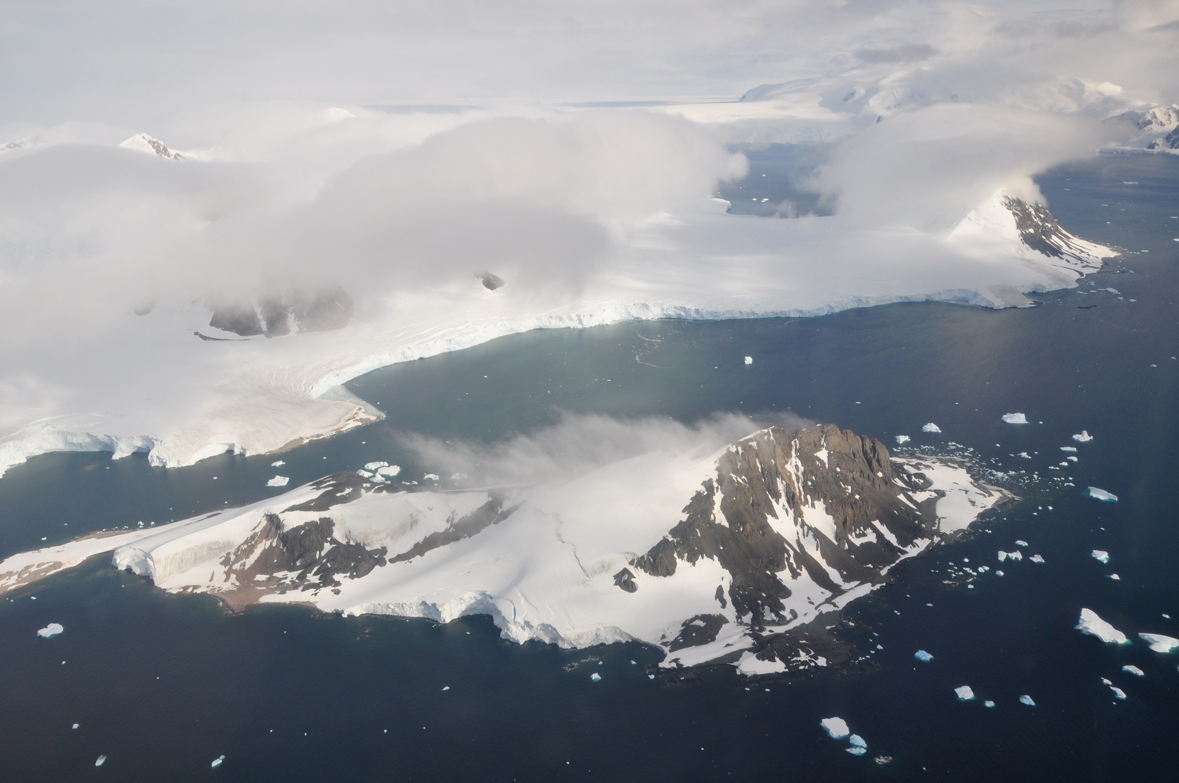
English:
This picture is from the SW Antarctic Peninsula region. It's an aerial view from a position over
Laubeuf Fjord
, looking to the NW. In the foreground is
Webb Island
with its summit of 398 m. Behind it is a part of the
Wright Peninsula
on
Adelaide Island
's east coast. This coast's high ice cliffs are from the
Wormald Ice Piedmont
that covers most of the Wright Peninsula's east coast. The cloud-covered mountains on the left are the
Stokes Peaks
. The lone cloud-covered mountain at the right -at the NE extremity of the Wright Peninsula-is
Sighing Peak
; behind it is Stonehouse Bay. The maritime channel right of Sighing Peak is called
Cole Channel
(and is actually a part of Laubeuf Fjord). In the upper right hand corner of the picture is the
Mount Bouvier
Massif. At the foot of these mountains the
Shambles Glacier
can just be seen through a hole in the clouds. It is Adelaide Island's largest glacier and is heavily crevassed.
|
| Date | |
| Source | Own work |
| Author | Vincent van Zeijst |
•
| Camera location |
|
View this and other nearby images on: OpenStreetMap |
|
|---|
,_Adelaide_Island,_Webb_Island.JPG¶ms=-67.465978_N_-067.884522_E_globe:Earth_type:camera_heading:315.00&language=en)
Licensing
I, the copyright holder of this work, hereby publish it under the following license:
This file is licensed under the
Creative Commons
Attribution-Share Alike 3.0 Unported
license.
-
You are free:
- to share – to copy, distribute and transmit the work
- to remix – to adapt the work
-
Under the following conditions:
- attribution – You must give appropriate credit, provide a link to the license, and indicate if changes were made. You may do so in any reasonable manner, but not in any way that suggests the licensor endorses you or your use.
- share alike – If you remix, transform, or build upon the material, you must distribute your contributions under the same or compatible license as the original.