Apple-2House_(10500_ft)_001.jpg

Size of this preview:
800 × 531 pixels
.
Other resolutions:
320 × 212 pixels
|
640 × 425 pixels
|
1,094 × 726 pixels
.
| Description |
English:
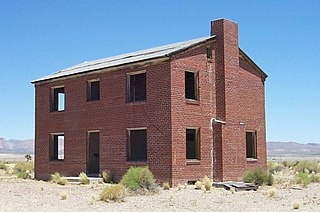
Nevada Test Site. Located 10,500 feet from Apple-2 ground zero, this two-story brick house was one of two identical structures erected for civil effects tests;
|
|||
| Source | Nevada National Security Site Tour Booklet, part 3 | |||
| Author | Federal Government of the United States | |||
|
Permission
( Reusing this file ) |
|

| Camera location |
|
View this and other nearby images on: OpenStreetMap |
|
|---|
_001.jpg¶ms=037.043000_N_-116.069736_E_globe:Earth_type:camera__&language=en)