Ascension_Island,_Wideawake_Airfield_(1).JPG

Size of this preview:
800 × 567 pixels
.
Other resolutions:
320 × 227 pixels
|
640 × 453 pixels
|
1,024 × 725 pixels
|
1,280 × 907 pixels
|
1,604 × 1,136 pixels
.
Summary
| Description |
English:
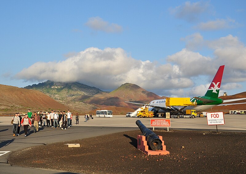
Wideawake Airfield on Ascension Island with a plane from Air Seychelles (on contract to the UK Ministry of Defence) to maintain the airlink between RAF Brize Norton in Oxfordshire and RAF Mount Pleasant in the Falkland Islands. Left of the centre is Green Mountain, the island's highest summit.
|
| Date | |
| Source | Own work |
| Author | Vincent van Zeijst |
| Camera location |
|
View this and other nearby images on: OpenStreetMap |
|
|---|
.JPG¶ms=-07.967853_N_-014.405019_E_globe:Earth_type:camera_region:SH_heading:90.00&language=en)
Licensing
I, the copyright holder of this work, hereby publish it under the following license:
This file is licensed under the
Creative Commons
Attribution-Share Alike 3.0 Unported
license.
-
You are free:
- to share – to copy, distribute and transmit the work
- to remix – to adapt the work
-
Under the following conditions:
- attribution – You must give appropriate credit, provide a link to the license, and indicate if changes were made. You may do so in any reasonable manner, but not in any way that suggests the licensor endorses you or your use.
- share alike – If you remix, transform, or build upon the material, you must distribute your contributions under the same or compatible license as the original.