Barra_Head_Lighthouse_cliffs.jpg

Size of this preview:
450 × 600 pixels
.
Other resolutions:
180 × 240 pixels
|
480 × 640 pixels
.
| Camera location |
|
View this and other nearby images on: OpenStreetMap |
|
|---|
_region:GB-GBN_heading:45.00&language=en)
| Object location |
|
View this and other nearby images on: OpenStreetMap |
|
|---|
_region:GB-GBN_heading:45.00&language=en)
| Description |
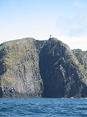
Français :
Le phare et les falaises de la côte Sud de Barra Head vus depuis la mer, Hébrides extérieures, Écosse
English:
Lighthouse and south coast cliffs of Barra Head, Outer Hebrides, Scotland from the sea
|
| Date | |
| Source | Geograph |
| Author | Tony Kinghorn |

|
This image was taken from the
Geograph project
collection. See
this photograph's page
on the Geograph website for the photographer's contact details. The copyright on this image is owned by
Tony Kinghorn
and is licensed for reuse under the
Creative Commons
Attribution-ShareAlike 2.0 license.
|
This file is licensed under the
Creative Commons
Attribution-Share Alike 2.0 Generic
license.
Attribution:
Tony Kinghorn
-
You are free:
- to share – to copy, distribute and transmit the work
- to remix – to adapt the work
-
Under the following conditions:
- attribution – You must give appropriate credit, provide a link to the license, and indicate if changes were made. You may do so in any reasonable manner, but not in any way that suggests the licensor endorses you or your use.
- share alike – If you remix, transform, or build upon the material, you must distribute your contributions under the same or compatible license as the original.