Belle_Grove,_Rappahannock_River,_Port_Royal,_Caroline_County,_VA.jpg

Size of this preview:
800 × 569 pixels
.
Other resolutions:
320 × 228 pixels
|
640 × 455 pixels
|
939 × 668 pixels
.
Summary
|
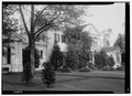
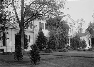
English: Belle Grove, Rappahannock River, Port Royal, Caroline County, VA
(
|
||||||||||||||||||||||||
|---|---|---|---|---|---|---|---|---|---|---|---|---|---|---|---|---|---|---|---|---|---|---|---|---|
| Photographer |
Thomas T. Waterman
|
|||||||||||||||||||||||
| Title |
English:
Belle Grove, Rappahannock River, Port Royal, Caroline County, VA
|
|||||||||||||||||||||||
| Description |
English:
Belle Grove, Rappahannock River, Port Royal, Caroline County, VA HABS VA,50-POCON.V,2--1
|
|||||||||||||||||||||||
| Date | 1941 | |||||||||||||||||||||||
| Medium | 5 x 7 in. | |||||||||||||||||||||||
| Collection |
|
|||||||||||||||||||||||
| Accession number |
HABS VA,50-POCON.V,2--1
|
|||||||||||||||||||||||
| Source |
|
|||||||||||||||||||||||
|
Permission
( Reusing this file ) |
Rights Advisory: No known restrictions on publication. | |||||||||||||||||||||||
| Other versions |
|
|||||||||||||||||||||||


| Camera location |
|
View this and other nearby images on: OpenStreetMap |
|
|---|
Licensing

|
This file comes from the
Historic American Buildings Survey (HABS), Historic American Engineering Record (HAER) or Historic American Landscapes Survey (HALS)
. These are programs of the National Park Service established for the purpose of documenting historic places. Records consist of measured drawings, archival photographs, and written reports.
|
|
|
This image or media file contains material based on a work of a National Park Service employee, created as part of that person's official duties. As a work of the U.S. federal government , such work is in the public domain in the United States. See the NPS website and NPS copyright policy for more information. |
|