Berlin-wall-map_en.svg

Size of this PNG preview of this SVG file:
766 × 600 pixels
.
Other resolutions:
307 × 240 pixels
|
613 × 480 pixels
|
981 × 768 pixels
|
1,280 × 1,002 pixels
|
2,560 × 2,004 pixels
|
2,701 × 2,114 pixels
.
Summary
| Description |
English:
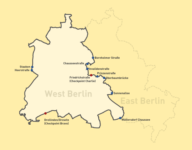
Map of the Berlin Wall, showing checkpoints. Key:
Français :
Carte du mur de Berlin avec les points de contrôle.
Deutsch:
Karte der Berliner Mauer, Kontrollpunkte gezeigt.
日本語:
西ベルリンを囲むベルリンの壁 丸い記号は国境検問所
Svenska:
Karta över Berlinmuren, visande gränsövergångar (korrigering: Staaten heter Staaken)
|
| Date | |
| Source | Own work , based on File:Occupied Berlin.svg by User:Stefan-Xp , derived from File:Berlin-wall-map.png by User:ChrisO . |
| Author | Ericmetro |
Licensing
ChrisO
, the copyright holder of this work, hereby publishes it under the following license:

|
Permission is granted to copy, distribute and/or modify this document under the terms of the GNU Free Documentation License , Version 1.2 or any later version published by the Free Software Foundation ; with no Invariant Sections, no Front-Cover Texts, and no Back-Cover Texts. A copy of the license is included in the section entitled GNU Free Documentation License . |
|
|
This file is licensed under the Creative Commons Attribution-Share Alike 3.0 Unported license. | |
| Attribution: ChrisO | ||
|
||
| This licensing tag was added to this file as part of the GFDL licensing update . |