BethesdaCDPmap.png
No higher resolution available.
Summary
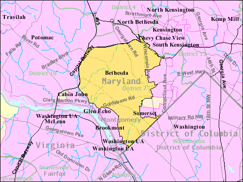
| Description | Boundaries of the Bethesda, Maryland , CDP as of 2003 |
| Date | |
| Source | http://factfinder.census.gov |
| Author | United States Census Bureau |
|
Permission
( Reusing this file ) |
Public domain |
Licensing
|
|
This image or file is a work of a
United States Census Bureau
employee, taken or made as part of that person's official duties. As a
work
of the
U.S. federal government
, the image is in the
public domain
.
|

|
Original upload log
This image was copied from wikipedia:en. Transwiki approved by: w:en:User:Dmcdevit
Original upload log
| date/time | username | resolution | size | edit summary |
|---|---|---|---|---|
| 23:07, 28 June 2005 | w:en:User:Doctor Whom | 500×375 | 43 KB | Boundaries of the Bethesda, Maryland, CDP as of 2003 {{PD-USGov-DOC-Census}} |
Image description page history
| link | date/time | username | edit summary |
|---|---|---|---|
| [1] | 08:11, 16 September 2007 | w:en:User:Dmcdevit | |
| [2] | 23:07, 28 June 2005 | w:en:User:Doctor Whom | (Boundaries of the Bethesda, Maryland, CDP as of 2003 {{PD-USGov-DOC-Census}}) |
![[1]](https://en.wikipedia.org/w/index.php?title=Image:BethesdaCDPmap.gif&redirect=no&oldid=17795173)
Original upload log
| Date/Time | Dimensions | User | Comment |
|---|---|---|---|
| 16 September 2007, 13:35:39 | 500 × 375 (43951 bytes) | BetacommandBot ( talk · contribs ) | Transwiki approved by: [[w:en:User:Dmcdevit]] This image was copied from wikipedia:en. The original description was: Boundaries of the Bethesda, Maryland, CDP as of 2003 {{PD-USGov-DOC-Census}} === File history === {| class=wikitable ! date/time || use |