Biot-map.png

No higher resolution available.

|
This
map
image could be re-created
using
vector graphics
as an
SVG
file
. This has several advantages; see
Commons:Media for cleanup
for more information. If an SVG form of this image is available, please upload it and afterwards replace this template with
{{

vector version available

|

new image name

}}
.
It is recommended to name the SVG file “Biot-map.svg”—then the template Vector version available (or Vva ) does not need the new image name parameter. |
Transferred from en.wikipedia to Commons by Maksim .
The original description page was
here
. All following user names refer to en.wikipedia.
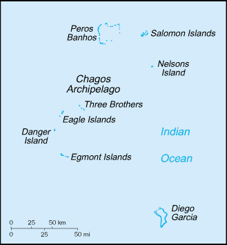
Map of the British Indian Ocean Territory from CIA World Factbook .
|
|
This image is in the
public domain
because it contains materials that originally came from the United States
Central Intelligence Agency
's
World Factbook
.
|

|
| date/time | username | edit summary |
|---|---|---|
| 22:56, 12 November 2004 | en:User:BrokenSegue | ({{PD-USGov-CIA-WF}}) |
| 06:17, 4 June 2004 | en:User:Template namespace initialisation script | |
| 20:15, 23 May 2004 | en:User:Grendelkhan | (clear up PD message) |
| 20:14, 23 May 2004 | en:User:Grendelkhan | (Map of the British Indian Ocean Territory from [http://www.lib.utexas.edu/maps/cia03/british_indian_ocean_sm03.gif CIA World Factbook].<br><br>{{msg:PD}}) |
Original upload log
Legend: (cur) = this is the current file, (del) = delete this old version, (rev) = revert to this old version.
Click on date to download the file or see the image uploaded on that date.
- (del) (cur) 22:14, 24 May 2005 . . en:User:Hoshie Hoshie ( en:User_talk:Hoshie Talk) . . 328x353 (4977 bytes) (updated map from 2005 CIA World Factbook, now with a lowercase file name.)
- (del) (rev) 20:14, 23 May 2004 . . en:User:Grendelkhan Grendelkhan ( en:User_talk:Grendelkhan Talk) . . 329x355 (4794 bytes) (Map of the British Indian Ocean Territory from CIA World Factbook .<br><br>{ { msg:PD } })