Blaeu_-_Nova_Belgica_et_Anglia_Nova.png

Size of this preview:
800 × 599 pixels
.
Other resolutions:
320 × 239 pixels
|
640 × 479 pixels
|
1,024 × 766 pixels
|
1,280 × 958 pixels
|
2,560 × 1,916 pixels
|
5,976 × 4,472 pixels
.
Summary
| Description |
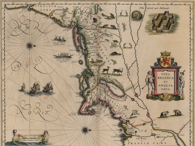
Nova Belgica et Anglia Nova , Amsterdam 1635 It is essentially an engraved version of Adriaen Block 's map of 1614 with some additions and subtractions. --DeKoning, April 17, 2006. Note: On this map the north direction is on the right border. The big sea is a part of the northern Atlantic. The land mass is the east coast of todays U.S.A. with mainly the new england (=Anglia Nova) countries. |
||||||||||||||||||||||||||
| Date | |||||||||||||||||||||||||||
| Source | Biblioteca Nacional de España | ||||||||||||||||||||||||||
| Author |
|
||||||||||||||||||||||||||
| Other versions |
|
||||||||||||||||||||||||||

_Blaeu_Map_c1634.jpg)
Licensing
|
|
This work is in the public domain in its country of origin and other countries and areas where the copyright term is the author's life plus 100 years or fewer . |
| This file has been identified as being free of known restrictions under copyright law, including all related and neighboring rights. | |