Blevins,_Arkansas_tornado_damage.jpg

Size of this preview:
800 × 600 pixels
.
Other resolutions:
320 × 240 pixels
|
640 × 480 pixels
|
1,024 × 768 pixels
|
1,280 × 960 pixels
|
2,048 × 1,536 pixels
.
Summary
| Description |
English:
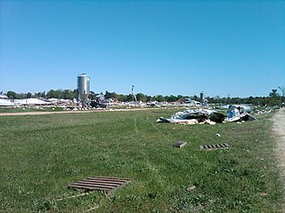
Four chicken houses that were destroyed by an EF2 tornado east of Blevins, Arkansas. Metal from the houses was thrown up to 3 miles away.
|
| Date | |
| Source | https://services.dat.noaa.gov/arcgis/rest/services/nws_damageassessmenttoolkit/DamageViewer/FeatureServer/0/29726/attachments/17111 |
| Author | NWS Shreveport |
| Camera location |
|
View this and other nearby images on: OpenStreetMap |
|
|---|
Licensing
|
|
This image is in the
public domain
because it contains materials that originally came from the U.S.
National Oceanic and Atmospheric Administration
, taken or made as part of an employee's official duties.
|
|