Brainerd_Mission_map.jpg
| Author |
|
| Description |
English:
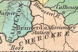
A beautiful example of Finley's important 1827 map of Tennessee. Depicts the state with moderate detail in Finley's classic minimalist style. Shows river ways, roads, canals, and some topographical features. Offers color coding at the county level. Title and scale in upper left quadrant. Finley's map of Tennessee is particularly interesting and important due to its portrayal of the rapidly changing American Indian situation in the south eastern part of the state. In 1827 a substantial part of southeastern Tennessee and northwestern Georgia was a confined territory assigned to the Lower Creek and Cherokee nations. Finley's map details the borders of this country as defined by the Tennessee and Hiwasssee Rivers. Also notes American Indian villages and missionary stations, including the Brainerd Mission, within and adjacent to the Cherokee territory. Just four years after this map was made the Creek and Cherokee would forcibly relocated westward in the infamous Trail of Tears. Engraved by Young and Delleker for the 1827 edition of Anthony Finley's General Atlas .
|
| Date | 1827 (undated) |
| Dimensions | height: 9 in (22.8 cm); width: 11.5 in (29.2 cm) |
| Accession number |
Geographicus link:
Tennessee-finley-1827
|
| Source/Photographer |
|
|
This is a
retouched picture
, which means that it has been digitally altered from its original version. Modifications:
cropped to focus on Brainerd Mission
. The original can be viewed here:
1827 Finley Map of Tennessee - Geographicus - Tennessee-finley-1827.jpg
:
|
|
This is a faithful photographic reproduction of a two-dimensional,
public domain
work of art. The work of art itself is in the public domain for the following reason:
The official position taken by the Wikimedia Foundation is that "
faithful reproductions of two-dimensional public domain works of art are public domain
".
This photographic reproduction is therefore also considered to be in the public domain in the United States. In other jurisdictions, re-use of this content may be restricted; see Reuse of PD-Art photographs for details. |
||||
Original upload log
This image is a derivative work of the following images:
-
File:1827_Finley_Map_of_Tennessee_-_Geographicus_-_Tennessee-finley-1827.jpg
licensed with Cc-pd-mark-footer, PD-Art, PD-old
- 2011-03-23T08:49:49Z BotMultichillT 3000x2279 (1612542 Bytes) {{subst:User:Multichill/Geographicus |link=http://www.geographicus.com/P/AntiqueMap/Tennessee-finley-1827 |product_name=1827 Finley Map of Tennessee |map_title=Tennessee. |description=A beautiful example of Finley's important
Uploaded with derivativeFX