CIAIranKarteOelGas.jpg

Size of this preview:
584 × 599 pixels
.
Other resolutions:
234 × 240 pixels
|
468 × 480 pixels
|
687 × 705 pixels
.
Summary

|
This file has been
superseded
by
Iran key Petroleum Sector facilities 2004.svg
. It is recommended to use the other file. Please note that deleting superseded images
requires consent
.
|

|
| Description |
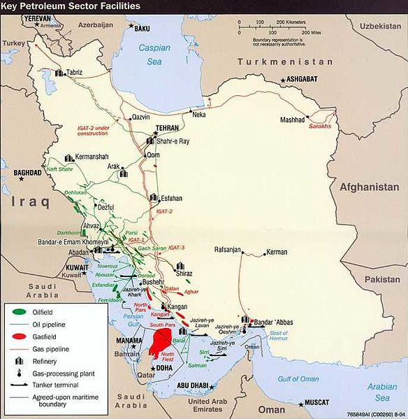
English:
Key Petroleum Sector facilities (2004)
Iran (Wall Map) 2004 "Iran Country Profile" Iran map with insets: Population Density, Ethnoreligious Distribution, Key Petroleum Sector Facilities, Southern Caspian Energy Prospects and Strait Of Hormuz (2.5M) (source: CIA map) http://www.lib.utexas.edu/maps/middle_east_and_asia/iran_country_profile_2004.jpg |
| Source | CIA World Fact Book |
| Author | CIA |
Licensing
|
|
This image is a work of a
Central Intelligence Agency
employee, taken or made as part of that person's official duties. As a Work of the United States Government, this image or media is in the
public domain
in the United States.
|

|
Original upload log
The original description page was
here
. All following user names refer to en.wikipedia.
- 2008-10-20 07:34 SSZ 687×705× (52497 bytes) Key Petroleum Sector facilities (2004) Iran (Wall Map) 2004 "Iran Country Profile" Iran map with insets: Population Density, Ethnoreligious Distribution, Key Petroleum Sector Facilities, Southern Caspian Energy Prospects and Strait Of Hormuz (2.5M) (sour