Canadian_River_Railroad_Bridge_Logan_New_Mexico_2010.jpg

Size of this preview:
800 × 586 pixels
.
Other resolutions:
320 × 234 pixels
|
640 × 468 pixels
|
1,024 × 749 pixels
|
1,280 × 937 pixels
|
2,560 × 1,874 pixels
|
2,816 × 2,061 pixels
.
Summary
| Description |
English:
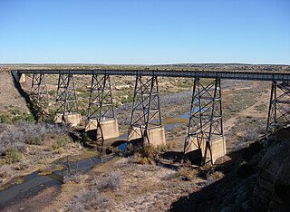
Railroad bridge spanning the
Canadian River
valley south of Logan, New Mexico.
This part of the Canadian River stopped flowing the day they closed the Ute Dam in 1963. In the past the river must have flowed strong enough to carve this magnificent canyon. Those days are over, however, as the Canadian River has become a valley without flowing water.
|
| Date | |
| Source | Own work |
| Author | Leaflet |
| Other versions | Photos of Eastern New Mexico |
| Camera location |
|
View this and other nearby images on: OpenStreetMap |
|
|---|
Licensing
I, the copyright holder of this work, hereby publish it under the following license:
This file is licensed under the
Creative Commons
Attribution-Share Alike 3.0 Unported
license.
-
You are free:
- to share – to copy, distribute and transmit the work
- to remix – to adapt the work
-
Under the following conditions:
- attribution – You must give appropriate credit, provide a link to the license, and indicate if changes were made. You may do so in any reasonable manner, but not in any way that suggests the licensor endorses you or your use.
- share alike – If you remix, transform, or build upon the material, you must distribute your contributions under the same or compatible license as the original.