Cano3.jpg

Size of this preview:
800 × 449 pixels
.
Other resolutions:
320 × 180 pixels
|
640 × 359 pixels
|
1,024 × 575 pixels
|
1,280 × 719 pixels
|
2,560 × 1,437 pixels
|
6,000 × 3,368 pixels
.
Summary
| Description |
English:
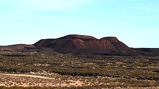
Pisgah crater/cinder cone is directly south of alongside route 66 and is 10 miles west of Ludlow California and about 30 miles southeast of Barstow California. The volcanic cone and basalt field is directly against an ancient ice age lake "Lavic Lake" The entire southern area of the cone and beyond is a marine corps gunnery range.
العربية:
تقع حفرة بسكة / مخروط الجمرة جنوبًا مباشرة بجانب الطريق 66 وعلى بعد 10 أميال غرب لودلو كاليفورنيا وحوالي 30 ميلاً جنوب شرق بارستو كاليفورنيا. يقع المخروط البركاني وحقل البازلت مباشرة مقابل بحيرة قديمة من العصر الجليدي "بحيرة لافيك" المنطقة الجنوبية بأكملها من المخروط وما وراءها هي مجموعة مدفعية لسلاح البحرية.
|
| Date | |
| Source | Own work |
| Author | Jeff Cuneo |
Licensing
I, the copyright holder of this work, hereby publish it under the following license:
This file is licensed under the
Creative Commons
Attribution-Share Alike 4.0 International
license.
-
You are free:
- to share – to copy, distribute and transmit the work
- to remix – to adapt the work
-
Under the following conditions:
- attribution – You must give appropriate credit, provide a link to the license, and indicate if changes were made. You may do so in any reasonable manner, but not in any way that suggests the licensor endorses you or your use.
- share alike – If you remix, transform, or build upon the material, you must distribute your contributions under the same or compatible license as the original.