Caroline_Islands-map.gif
No higher resolution available.

|
This
map
image could be re-created
using
vector graphics
as an
SVG
file
. This has several advantages; see
Commons:Media for cleanup
for more information. If an SVG form of this image is available, please upload it and afterwards replace this template with
{{

vector version available

|

new image name

}}
.
It is recommended to name the SVG file “Caroline Islands-map.svg”—then the template Vector version available (or Vva ) does not need the new image name parameter. |
Summary
-
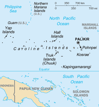
English: Map of the Caroline Islands Archipelago — located in the Micronesia region of Oceania, in the western Pacific Ocean.
-
-
-
- The central and western islands are in the Federated States of Micronesia , and the eastern are in the Republic of Palau .
- The archipelago is north of the island of New Guinea and the Salomon Islands Archipelago .
-
-
Credits
- From https://www.cia.gov/library/publications/the-world-factbook/geos/fm.html archive copy at the Wayback Machine
|
|
This image is in the
public domain
because it contains materials that originally came from the United States
Central Intelligence Agency
's
World Factbook
.
|

|